You are here: Home > Network List > MN - MEDNET Project Stations List
> Station KEG Kottamya, Egypt > Earthquake Result Viewer
KEG Kottamya, Egypt - Earthquake Result Viewer
| Earthquake location: |
Eastern Sea Of Japan |
| Earthquake latitude/longitude: |
43.2/138.9 |
| Earthquake time(UTC): |
1996/12/22 (357) 14:53:27 GMT |
| Earthquake Depth: |
227 km |
| Earthquake Magnitude: |
6.0 MB, 6.5 UNKNOWN, 6.5 MW |
| Earthquake Catalog/Contributor: |
WHDF/NEIC |
|
| Network: |
MN MEDNET Project |
| Station: |
KEG Kottamya, Egypt |
| Lat/Lon: |
29.93 N/31.83 E |
| Elevation: |
460 m |
|
| Distance: |
81.3 deg |
| Az: |
302.909 deg |
| Baz: |
45.0 deg |
| Ray Param: |
0.047141366 |
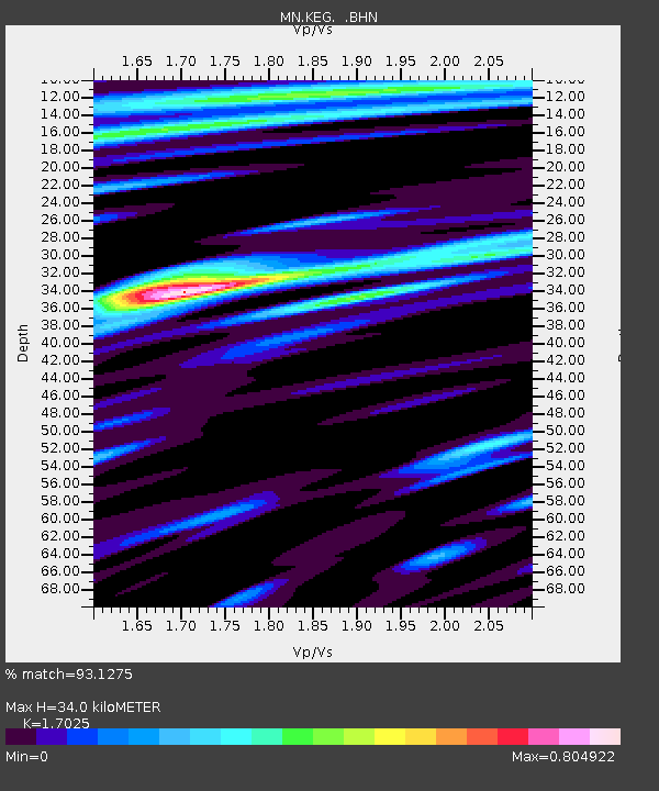
| Estimated Moho Depth: |
34.0 km |
| Estimated Crust Vp/Vs: |
1.70 |
| Assumed Crust Vp: |
6.312 km/s |
| Estimated Crust Vs: |
3.708 km/s |
| Estimated Crust Poisson's Ratio: |
0.24 |
|
| Radial Match: |
93.1275 % |
| Radial Bump: |
400 |
| Transverse Match: |
92.702705 % |
| Transverse Bump: |
400 |
| SOD ConfigId: |
6273 |
| Insert Time: |
2010-03-08 17:14:22.344 +0000 |
| GWidth: |
2.5 |
| Max Bumps: |
400 |
| Tol: |
0.001 |
|
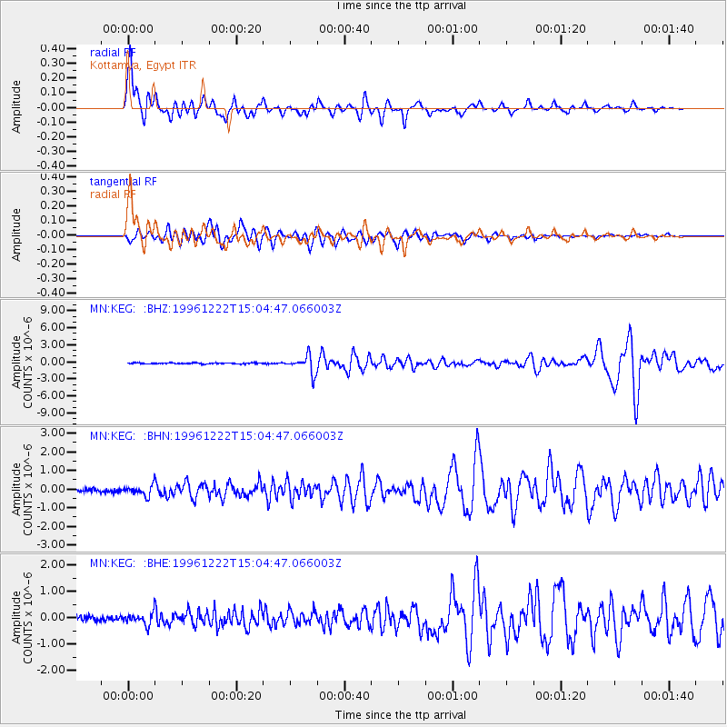
Signal To Noise
| Channel | StoN | STA | LTA |
| MN:KEG: :BHN:19961222T15:04:47.066003Z | 2.9539013 | 2.9037753E-7 | 9.830306E-8 |
| MN:KEG: :BHE:19961222T15:04:47.066003Z | 2.4806004 | 2.2913763E-7 | 9.237184E-8 |
| MN:KEG: :BHZ:19961222T15:04:47.066003Z | 16.677391 | 1.5714235E-6 | 9.422478E-8 |
| Arrivals |
| Ps | 3.9 SECOND |
| PpPs | 14 SECOND |
| PsPs/PpSs | 18 SECOND |


