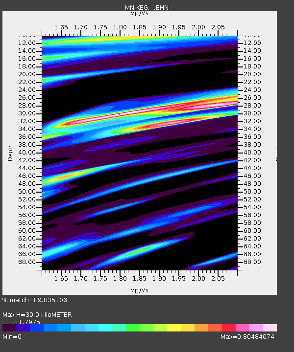
KEG Kottamya, Egypt - Earthquake Result Viewer
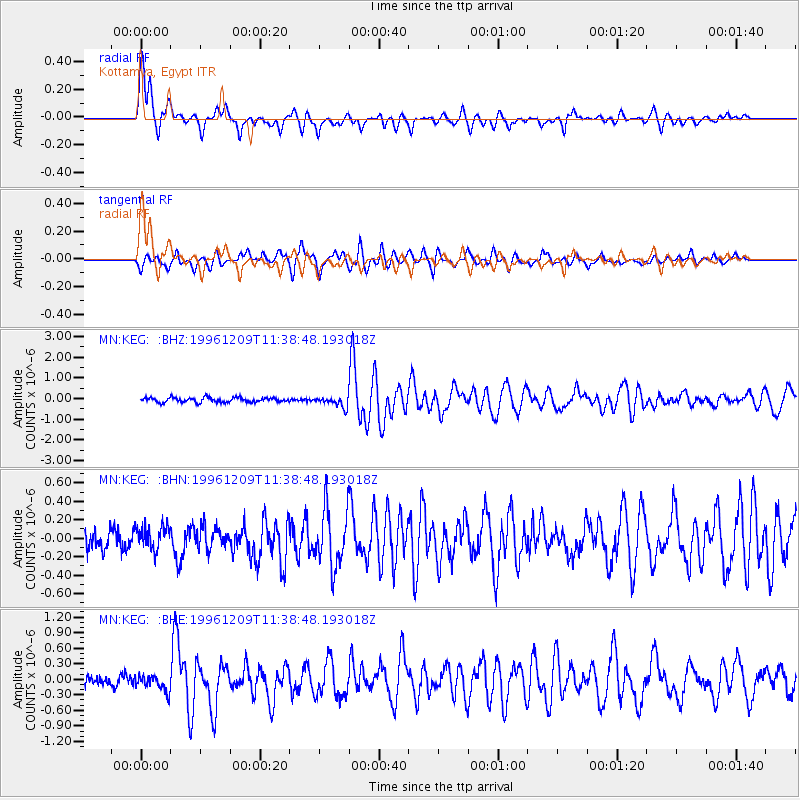
Earthquake location: Northern Mid-Atlantic Ridge
Earthquake latitude/longitude: 29.9/-42.9
Earthquake time(UTC): 1996/12/09 (344) 11:28:48 GMT
Earthquake Depth: 10 km
Earthquake Magnitude: 5.9 MB, 6.1 MS, 6.0 UNKNOWN, 5.9 MW
Earthquake Catalog/Contributor: WHDF/NEIC
Network: MN MEDNET Project
Station: KEG Kottamya, Egypt
Lat/Lon: 29.93 N/31.83 E
Elevation: 460 m
Distance: 63.6 deg
Az: 69.221 deg
Baz: 290.662 deg
Ray Param: 0.05948841
Estimated Moho Depth: 30.0 km
Estimated Crust Vp/Vs: 1.80
Assumed Crust Vp: 6.312 km/s
Estimated Crust Vs: 3.512 km/s
Estimated Crust Poisson's Ratio: 0.28
Radial Match: 89.835106 %
Radial Bump: 376
Transverse Match: 83.9815 %
Transverse Bump: 400
SOD ConfigId: 6273
Insert Time: 2010-03-08 17:14:23.486 +0000
GWidth: 2.5
Max Bumps: 400
Tol: 0.001

Signal To Noise

ChannelStoNSTALTA
MN:KEG: :BHN:19961209T11:38:48.193018Z1.27190321.278996E-71.0055765E-7
MN:KEG: :BHE:19961209T11:38:48.193018Z1.93029831.5462713E-78.01053E-8
MN:KEG: :BHZ:19961209T11:38:48.193018Z2.19351362.5093044E-71.1439657E-7
Arrivals
Ps3.9 SECOND
PpPs13 SECOND
PsPs/PpSs17 SECOND