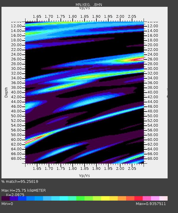
KEG Kottamya, Egypt - Earthquake Result Viewer
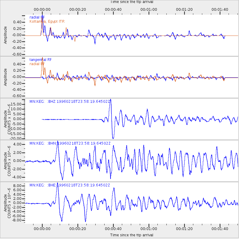
Earthquake location: North Of Ascension Island
Earthquake latitude/longitude: -1.3/-14.3
Earthquake time(UTC): 1996/02/18 (049) 23:49:28 GMT
Earthquake Depth: 10 km
Earthquake Magnitude: 6.3 MB, 6.4 MS, 6.6 UNKNOWN, 6.5 MW
Earthquake Catalog/Contributor: WHDF/NEIC
Network: MN MEDNET Project
Station: KEG Kottamya, Egypt
Lat/Lon: 29.93 N/31.83 E
Elevation: 460 m
Distance: 53.8 deg
Az: 50.829 deg
Baz: 243.232 deg
Ray Param: 0.06586264
Estimated Moho Depth: 25.75 km
Estimated Crust Vp/Vs: 2.10
Assumed Crust Vp: 6.312 km/s
Estimated Crust Vs: 3.01 km/s
Estimated Crust Poisson's Ratio: 0.35
Radial Match: 95.25819 %
Radial Bump: 400
Transverse Match: 89.503 %
Transverse Bump: 400
SOD ConfigId: 6273
Insert Time: 2010-03-08 17:14:44.504 +0000
GWidth: 2.5
Max Bumps: 400
Tol: 0.001

Signal To Noise

ChannelStoNSTALTA
MN:KEG: :BHN:19960218T23:58:19.64502Z2.05975961.6064982E-77.799445E-8
MN:KEG: :BHE:19960218T23:58:19.64502Z4.98908663.8889257E-77.794865E-8
MN:KEG: :BHZ:19960218T23:58:19.64502Z10.0876547.7234546E-77.656343E-8
Arrivals
Ps4.7 SECOND
PpPs12 SECOND
PsPs/PpSs17 SECOND