You are here: Home > Network List > MN - MEDNET Project Stations List
> Station KEG Kottamya, Egypt > Earthquake Result Viewer
KEG Kottamya, Egypt - Earthquake Result Viewer
| Earthquake location: |
Kuril Islands |
| Earthquake latitude/longitude: |
45.2/148.6 |
| Earthquake time(UTC): |
1996/02/22 (053) 14:59:09 GMT |
| Earthquake Depth: |
133 km |
| Earthquake Magnitude: |
6.2 MB, 6.3 UNKNOWN, 6.3 MW |
| Earthquake Catalog/Contributor: |
WHDF/NEIC |
|
| Network: |
MN MEDNET Project |
| Station: |
KEG Kottamya, Egypt |
| Lat/Lon: |
29.93 N/31.83 E |
| Elevation: |
460 m |
|
| Distance: |
85.7 deg |
| Az: |
308.964 deg |
| Baz: |
39.284 deg |
| Ray Param: |
0.044288803 |
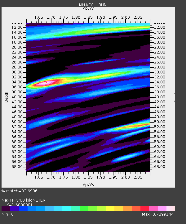
| Estimated Moho Depth: |
34.0 km |
| Estimated Crust Vp/Vs: |
1.68 |
| Assumed Crust Vp: |
6.312 km/s |
| Estimated Crust Vs: |
3.757 km/s |
| Estimated Crust Poisson's Ratio: |
0.23 |
|
| Radial Match: |
93.6936 % |
| Radial Bump: |
400 |
| Transverse Match: |
91.23392 % |
| Transverse Bump: |
400 |
| SOD ConfigId: |
6273 |
| Insert Time: |
2010-03-08 17:14:45.591 +0000 |
| GWidth: |
2.5 |
| Max Bumps: |
400 |
| Tol: |
0.001 |
|
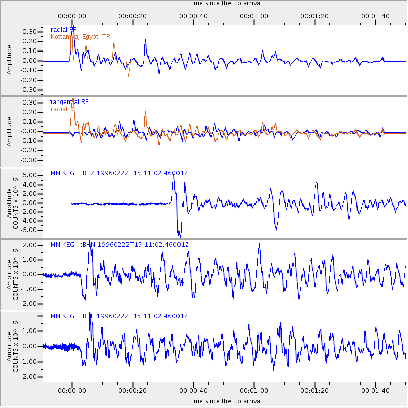
Signal To Noise
| Channel | StoN | STA | LTA |
| MN:KEG: :BHN:19960222T15:11:02.46001Z | 8.454761 | 7.057492E-7 | 8.3473594E-8 |
| MN:KEG: :BHE:19960222T15:11:02.46001Z | 7.302667 | 5.339069E-7 | 7.3111224E-8 |
| MN:KEG: :BHZ:19960222T15:11:02.46001Z | 28.556067 | 2.2655822E-6 | 7.933804E-8 |
| Arrivals |
| Ps | 3.8 SECOND |
| PpPs | 14 SECOND |
| PsPs/PpSs | 18 SECOND |


