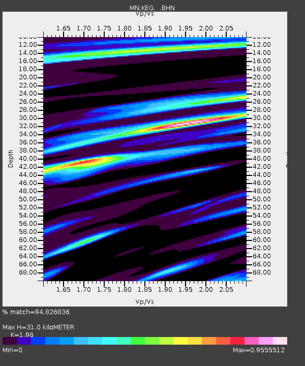
KEG Kottamya, Egypt - Earthquake Result Viewer
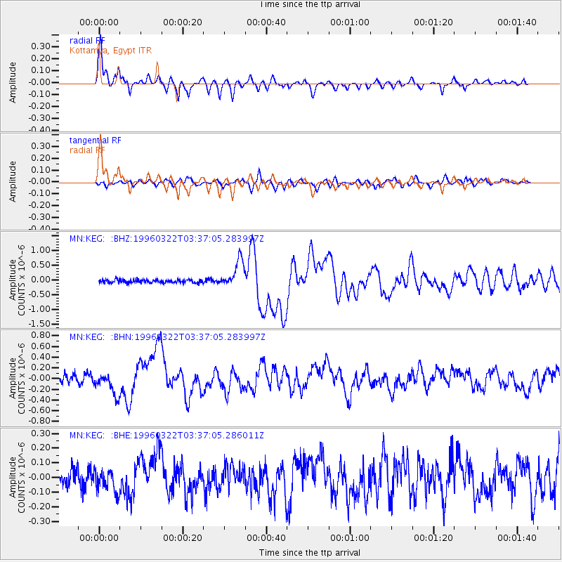
Earthquake location: Rat Islands, Aleutian Islands
Earthquake latitude/longitude: 51.2/178.7
Earthquake time(UTC): 1996/03/22 (082) 03:24:20 GMT
Earthquake Depth: 20 km
Earthquake Magnitude: 5.7 MB, 6.6 MS, 6.8 UNKNOWN, 6.6 ML
Earthquake Catalog/Contributor: WHDF/NEIC
Network: MN MEDNET Project
Station: KEG Kottamya, Egypt
Lat/Lon: 29.93 N/31.83 E
Elevation: 460 m
Distance: 94.1 deg
Az: 331.594 deg
Baz: 20.158 deg
Ray Param: 0.041121338
Estimated Moho Depth: 31.0 km
Estimated Crust Vp/Vs: 1.96
Assumed Crust Vp: 6.312 km/s
Estimated Crust Vs: 3.221 km/s
Estimated Crust Poisson's Ratio: 0.32
Radial Match: 94.826836 %
Radial Bump: 383
Transverse Match: 76.96953 %
Transverse Bump: 400
SOD ConfigId: 6273
Insert Time: 2010-03-08 17:14:49.384 +0000
GWidth: 2.5
Max Bumps: 400
Tol: 0.001

Signal To Noise

ChannelStoNSTALTA
MN:KEG: :BHN:19960322T03:37:05.283997Z3.06416442.1353888E-76.968911E-8
MN:KEG: :BHE:19960322T03:37:05.286011Z1.19488587.5741454E-86.338803E-8
MN:KEG: :BHZ:19960322T03:37:05.283997Z8.9754314.783538E-75.3295906E-8
Arrivals
Ps4.8 SECOND
PpPs14 SECOND
PsPs/PpSs19 SECOND