You are here: Home > Network List > MN - MEDNET Project Stations List
> Station KEG Kottamya, Egypt > Earthquake Result Viewer
KEG Kottamya, Egypt - Earthquake Result Viewer
| Earthquake location: |
Kuril Islands |
| Earthquake latitude/longitude: |
43.7/147.6 |
| Earthquake time(UTC): |
1996/05/07 (128) 23:20:00 GMT |
| Earthquake Depth: |
54 km |
| Earthquake Magnitude: |
6.2 MB, 5.6 MS, 6.2 UNKNOWN, 5.2 MS |
| Earthquake Catalog/Contributor: |
WHDF/NEIC |
|
| Network: |
MN MEDNET Project |
| Station: |
KEG Kottamya, Egypt |
| Lat/Lon: |
29.93 N/31.83 E |
| Elevation: |
460 m |
|
| Distance: |
86.1 deg |
| Az: |
308.415 deg |
| Baz: |
40.884 deg |
| Ray Param: |
0.044199187 |
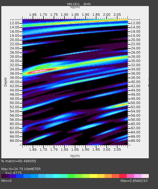
| Estimated Moho Depth: |
34.75 km |
| Estimated Crust Vp/Vs: |
1.68 |
| Assumed Crust Vp: |
6.312 km/s |
| Estimated Crust Vs: |
3.763 km/s |
| Estimated Crust Poisson's Ratio: |
0.22 |
|
| Radial Match: |
90.469055 % |
| Radial Bump: |
400 |
| Transverse Match: |
89.351105 % |
| Transverse Bump: |
400 |
| SOD ConfigId: |
6273 |
| Insert Time: |
2010-03-08 17:14:50.654 +0000 |
| GWidth: |
2.5 |
| Max Bumps: |
400 |
| Tol: |
0.001 |
|
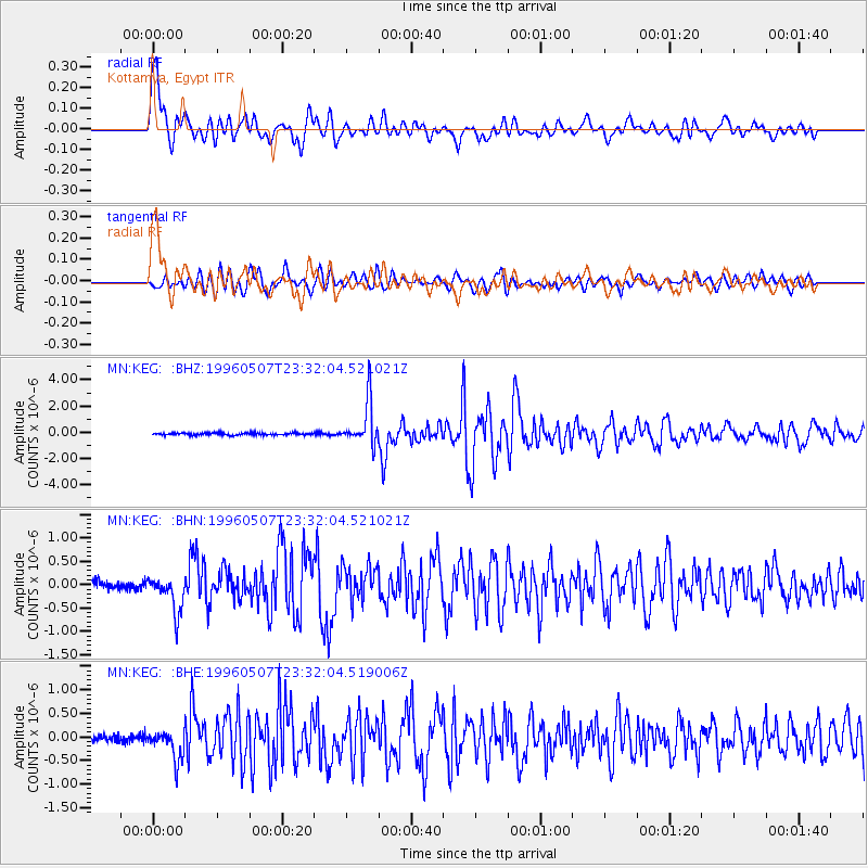
Signal To Noise
| Channel | StoN | STA | LTA |
| MN:KEG: :BHN:19960507T23:32:04.521021Z | 4.121514 | 3.8259986E-7 | 9.282994E-8 |
| MN:KEG: :BHE:19960507T23:32:04.519006Z | 4.473883 | 3.0913026E-7 | 6.9096636E-8 |
| MN:KEG: :BHZ:19960507T23:32:04.521021Z | 20.056572 | 1.6606665E-6 | 8.2799126E-8 |
| Arrivals |
| Ps | 3.8 SECOND |
| PpPs | 14 SECOND |
| PsPs/PpSs | 18 SECOND |


