You are here: Home > Network List > MN - MEDNET Project Stations List
> Station KEG Kottamya, Egypt > Earthquake Result Viewer
KEG Kottamya, Egypt - Earthquake Result Viewer
| Earthquake location: |
Samar, Philippines |
| Earthquake latitude/longitude: |
12.6/125.2 |
| Earthquake time(UTC): |
1996/06/11 (163) 18:22:55 GMT |
| Earthquake Depth: |
33 km |
| Earthquake Magnitude: |
6.0 MB, 7.0 MS, 7.2 UNKNOWN, 7.1 MW |
| Earthquake Catalog/Contributor: |
WHDF/NEIC |
|
| Network: |
MN MEDNET Project |
| Station: |
KEG Kottamya, Egypt |
| Lat/Lon: |
29.93 N/31.83 E |
| Elevation: |
460 m |
|
| Distance: |
86.6 deg |
| Az: |
299.758 deg |
| Baz: |
77.476 deg |
| Ray Param: |
0.0438601 |
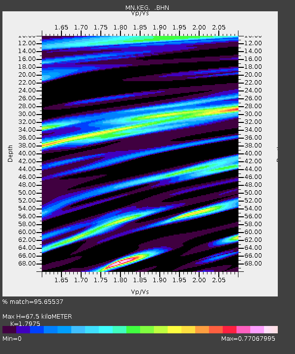
| Estimated Moho Depth: |
67.5 km |
| Estimated Crust Vp/Vs: |
1.80 |
| Assumed Crust Vp: |
6.312 km/s |
| Estimated Crust Vs: |
3.512 km/s |
| Estimated Crust Poisson's Ratio: |
0.28 |
|
| Radial Match: |
95.65537 % |
| Radial Bump: |
400 |
| Transverse Match: |
88.88386 % |
| Transverse Bump: |
400 |
| SOD ConfigId: |
6273 |
| Insert Time: |
2010-03-08 17:14:53.496 +0000 |
| GWidth: |
2.5 |
| Max Bumps: |
400 |
| Tol: |
0.001 |
|
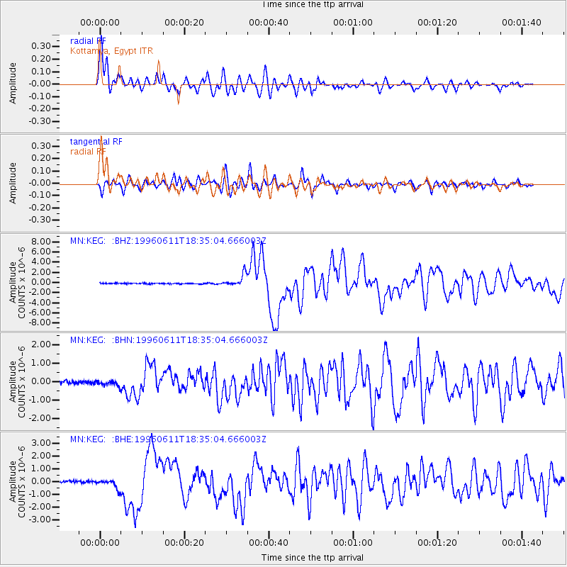
Signal To Noise
| Channel | StoN | STA | LTA |
| MN:KEG: :BHN:19960611T18:35:04.666003Z | 1.8190128 | 1.4621868E-7 | 8.038354E-8 |
| MN:KEG: :BHE:19960611T18:35:04.666003Z | 4.919217 | 3.5979602E-7 | 7.314091E-8 |
| MN:KEG: :BHZ:19960611T18:35:04.666003Z | 15.215377 | 1.2257012E-6 | 8.0556745E-8 |
| Arrivals |
| Ps | 8.7 SECOND |
| PpPs | 29 SECOND |
| PsPs/PpSs | 38 SECOND |


