You are here: Home > Network List > MN - MEDNET Project Stations List
> Station KEG Kottamya, Egypt > Earthquake Result Viewer
KEG Kottamya, Egypt - Earthquake Result Viewer
| Earthquake location: |
Leeward Islands |
| Earthquake latitude/longitude: |
15.2/-61.4 |
| Earthquake time(UTC): |
1996/09/24 (268) 11:42:18 GMT |
| Earthquake Depth: |
147 km |
| Earthquake Magnitude: |
6.0 MB, 5.9 UNKNOWN, 5.7 MW |
| Earthquake Catalog/Contributor: |
WHDF/NEIC |
|
| Network: |
MN MEDNET Project |
| Station: |
KEG Kottamya, Egypt |
| Lat/Lon: |
29.93 N/31.83 E |
| Elevation: |
460 m |
|
| Distance: |
85.3 deg |
| Az: |
60.409 deg |
| Baz: |
284.73 deg |
| Ray Param: |
0.044508927 |
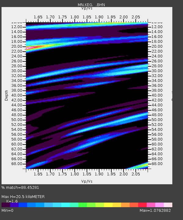
| Estimated Moho Depth: |
20.5 km |
| Estimated Crust Vp/Vs: |
1.60 |
| Assumed Crust Vp: |
6.312 km/s |
| Estimated Crust Vs: |
3.945 km/s |
| Estimated Crust Poisson's Ratio: |
0.18 |
|
| Radial Match: |
88.45281 % |
| Radial Bump: |
400 |
| Transverse Match: |
82.19946 % |
| Transverse Bump: |
400 |
| SOD ConfigId: |
6273 |
| Insert Time: |
2010-03-08 17:15:01.002 +0000 |
| GWidth: |
2.5 |
| Max Bumps: |
400 |
| Tol: |
0.001 |
|
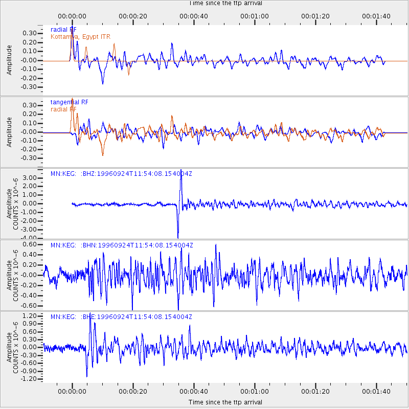
Signal To Noise
| Channel | StoN | STA | LTA |
| MN:KEG: :BHN:19960924T11:54:08.154004Z | 0.7999244 | 6.878678E-8 | 8.599161E-8 |
| MN:KEG: :BHE:19960924T11:54:08.154004Z | 2.5158784 | 2.1569315E-7 | 8.573274E-8 |
| MN:KEG: :BHZ:19960924T11:54:08.154004Z | 9.863722 | 7.5338465E-7 | 7.637935E-8 |
| Arrivals |
| Ps | 2.0 SECOND |
| PpPs | 8.2 SECOND |
| PsPs/PpSs | 10 SECOND |


