You are here: Home > Network List > MN - MEDNET Project Stations List
> Station KEG Kottamya, Egypt > Earthquake Result Viewer
KEG Kottamya, Egypt - Earthquake Result Viewer
| Earthquake location: |
Eastern Kashmir |
| Earthquake latitude/longitude: |
35.3/78.1 |
| Earthquake time(UTC): |
1996/11/19 (324) 10:44:46 GMT |
| Earthquake Depth: |
33 km |
| Earthquake Magnitude: |
6.1 MB, 7.1 MS, 6.9 UNKNOWN, 6.8 MW |
| Earthquake Catalog/Contributor: |
WHDF/NEIC |
|
| Network: |
MN MEDNET Project |
| Station: |
KEG Kottamya, Egypt |
| Lat/Lon: |
29.93 N/31.83 E |
| Elevation: |
460 m |
|
| Distance: |
39.1 deg |
| Az: |
275.499 deg |
| Baz: |
69.618 deg |
| Ray Param: |
0.075121455 |
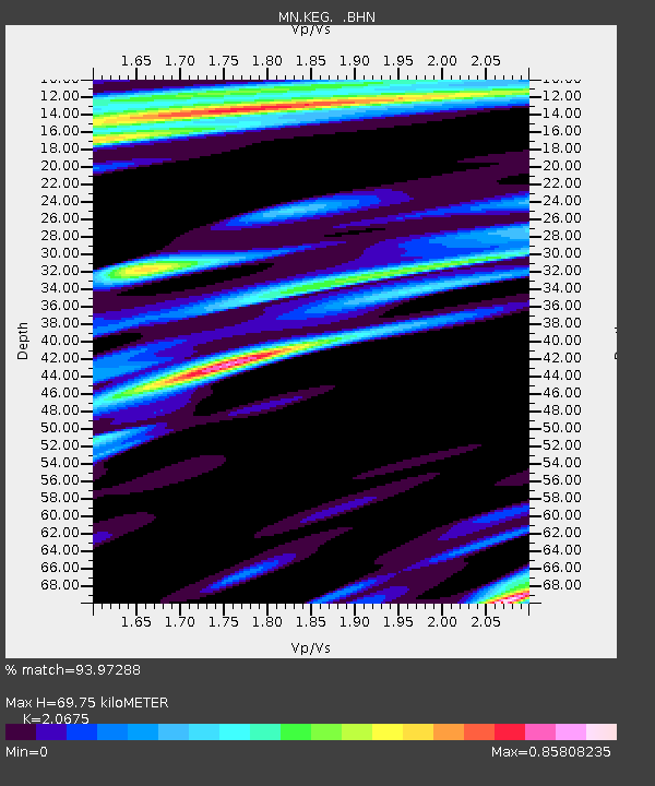
| Estimated Moho Depth: |
69.75 km |
| Estimated Crust Vp/Vs: |
2.07 |
| Assumed Crust Vp: |
6.312 km/s |
| Estimated Crust Vs: |
3.053 km/s |
| Estimated Crust Poisson's Ratio: |
0.35 |
|
| Radial Match: |
93.97288 % |
| Radial Bump: |
309 |
| Transverse Match: |
79.724594 % |
| Transverse Bump: |
400 |
| SOD ConfigId: |
6273 |
| Insert Time: |
2010-03-08 17:15:05.969 +0000 |
| GWidth: |
2.5 |
| Max Bumps: |
400 |
| Tol: |
0.001 |
|
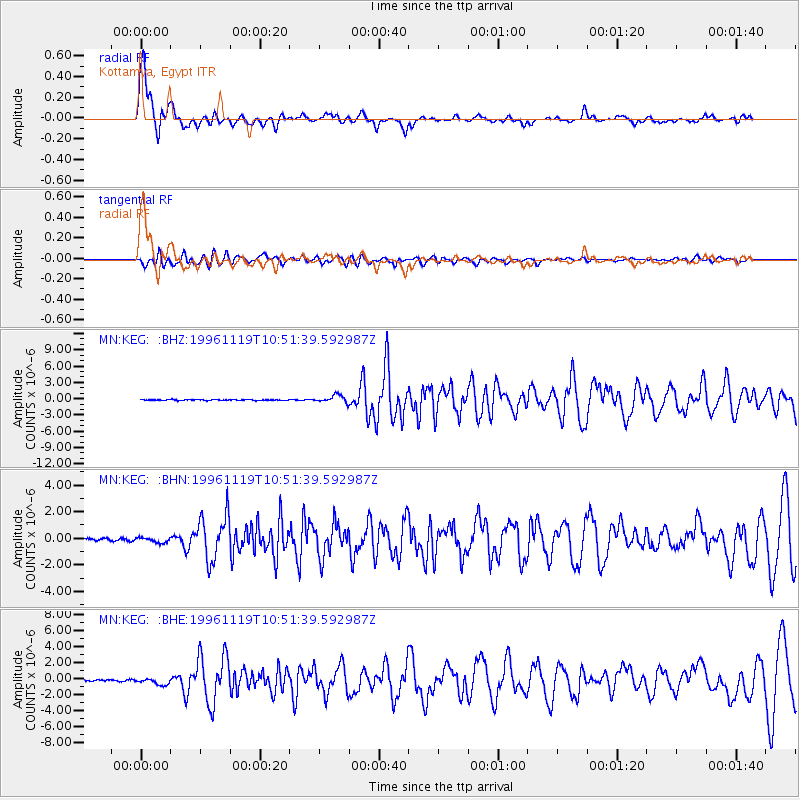
Signal To Noise
| Channel | StoN | STA | LTA |
| MN:KEG: :BHN:19961119T10:51:39.592987Z | 2.0472338 | 1.8361838E-7 | 8.9690964E-8 |
| MN:KEG: :BHE:19961119T10:51:39.592987Z | 5.4070306 | 3.8958345E-7 | 7.205128E-8 |
| MN:KEG: :BHZ:19961119T10:51:39.592987Z | 8.916916 | 6.956575E-7 | 7.801549E-8 |
| Arrivals |
| Ps | 13 SECOND |
| PpPs | 32 SECOND |
| PsPs/PpSs | 44 SECOND |


