You are here: Home > Network List > MN - MEDNET Project Stations List
> Station KEG Kottamya, Egypt > Earthquake Result Viewer
KEG Kottamya, Egypt - Earthquake Result Viewer
| Earthquake location: |
Ryukyu Islands, Japan |
| Earthquake latitude/longitude: |
28.8/130.0 |
| Earthquake time(UTC): |
1997/01/17 (017) 15:53:13 GMT |
| Earthquake Depth: |
33 km |
| Earthquake Magnitude: |
5.9 MB, 6.3 MS, 6.3 UNKNOWN, 6.2 MW |
| Earthquake Catalog/Contributor: |
WHDF/NEIC |
|
| Network: |
MN MEDNET Project |
| Station: |
KEG Kottamya, Egypt |
| Lat/Lon: |
29.93 N/31.83 E |
| Elevation: |
460 m |
|
| Distance: |
82.5 deg |
| Az: |
299.913 deg |
| Baz: |
61.19 deg |
| Ray Param: |
0.046793755 |
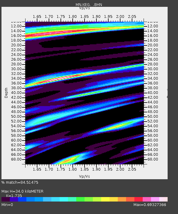
| Estimated Moho Depth: |
34.0 km |
| Estimated Crust Vp/Vs: |
1.74 |
| Assumed Crust Vp: |
6.312 km/s |
| Estimated Crust Vs: |
3.638 km/s |
| Estimated Crust Poisson's Ratio: |
0.25 |
|
| Radial Match: |
84.51475 % |
| Radial Bump: |
400 |
| Transverse Match: |
84.69331 % |
| Transverse Bump: |
400 |
| SOD ConfigId: |
6273 |
| Insert Time: |
2010-03-08 17:15:11.390 +0000 |
| GWidth: |
2.5 |
| Max Bumps: |
400 |
| Tol: |
0.001 |
|
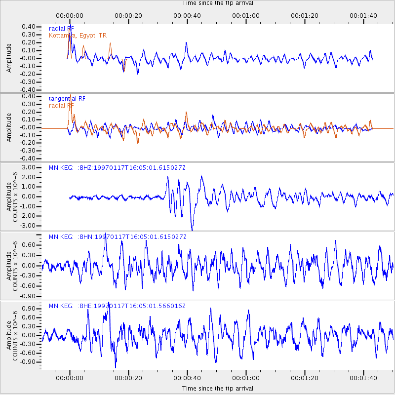
Signal To Noise
| Channel | StoN | STA | LTA |
| MN:KEG: :BHN:19970117T16:05:01.615027Z | 1.3657665 | 1.9566544E-7 | 1.4326419E-7 |
| MN:KEG: :BHE:19970117T16:05:01.566016Z | 2.0248704 | 2.0900723E-7 | 1.0322005E-7 |
| MN:KEG: :BHZ:19970117T16:05:01.615027Z | 7.087769 | 8.0222924E-7 | 1.1318501E-7 |
| Arrivals |
| Ps | 4.1 SECOND |
| PpPs | 14 SECOND |
| PsPs/PpSs | 18 SECOND |


