You are here: Home > Network List > CN - Canadian National Seismograph Network Stations List
> Station INK INUVIK, NT > Earthquake Result Viewer
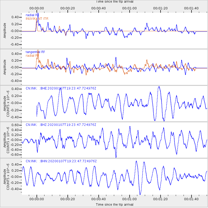
INK INUVIK, NT - Earthquake Result Viewer
*The percent match for this event was below the threshold and hence no stack was calculated.
| Earthquake location: |
New Britain Region, P.N.G. |
| Earthquake latitude/longitude: |
-5.2/151.2 |
| Earthquake time(UTC): |
2020/01/07 (007) 19:11:35 GMT |
| Earthquake Depth: |
117 km |
| Earthquake Magnitude: |
6.0 Mww |
| Earthquake Catalog/Contributor: |
NEIC PDE/us |
|
| Network: |
CN Canadian National Seismograph Network |
| Station: |
INK INUVIK, NT |
| Lat/Lon: |
68.31 N/133.53 W |
| Elevation: |
44 m |
|
| Distance: |
89.4 deg |
| Az: |
21.072 deg |
| Baz: |
254.402 deg |
| Ray Param: |
$rayparam |
*The percent match for this event was below the threshold and hence was not used in the summary stack. |
|
| Radial Match: |
74.20029 % |
| Radial Bump: |
400 |
| Transverse Match: |
62.56895 % |
| Transverse Bump: |
400 |
| SOD ConfigId: |
20465011 |
| Insert Time: |
2020-01-21 19:17:33.933 +0000 |
| GWidth: |
2.5 |
| Max Bumps: |
400 |
| Tol: |
0.001 |
|
Signal To Noise
| Channel | StoN | STA | LTA |
| CN:INK: :BHZ:20200107T19:23:47.724976Z | 0.985747 | 1.9903042E-7 | 2.0190822E-7 |
| CN:INK: :BHN:20200107T19:23:47.724976Z | 0.6557151 | 1.26723E-7 | 1.9325924E-7 |
| CN:INK: :BHE:20200107T19:23:47.724976Z | 1.1671237 | 2.4291438E-7 | 2.081308E-7 |
| Arrivals |
| Ps | |
| PpPs | |
| PsPs/PpSs | |


