You are here: Home > Network List > TA - USArray Transportable Network (new EarthScope stations) Stations List
> Station G16K Koyuk River, AK, USA > Earthquake Result Viewer
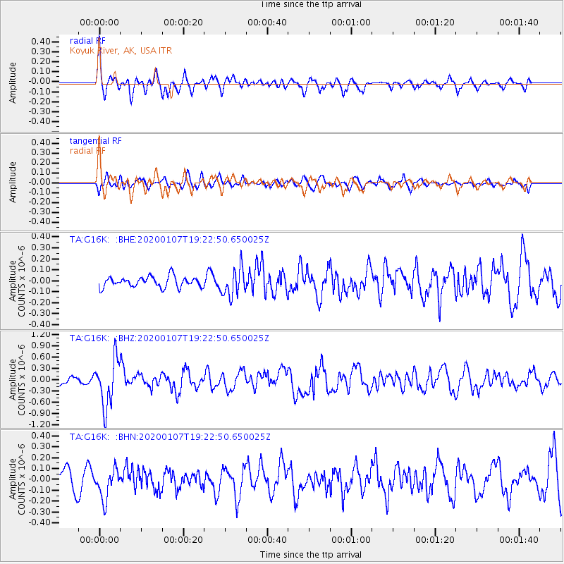
G16K Koyuk River, AK, USA - Earthquake Result Viewer
*The percent match for this event was below the threshold and hence no stack was calculated.
| Earthquake location: |
New Britain Region, P.N.G. |
| Earthquake latitude/longitude: |
-5.2/151.2 |
| Earthquake time(UTC): |
2020/01/07 (007) 19:11:35 GMT |
| Earthquake Depth: |
117 km |
| Earthquake Magnitude: |
6.0 Mww |
| Earthquake Catalog/Contributor: |
NEIC PDE/us |
|
| Network: |
TA USArray Transportable Network (new EarthScope stations) |
| Station: |
G16K Koyuk River, AK, USA |
| Lat/Lon: |
65.39 N/162.35 W |
| Elevation: |
169 m |
|
| Distance: |
78.1 deg |
| Az: |
18.054 deg |
| Baz: |
227.495 deg |
| Ray Param: |
$rayparam |
*The percent match for this event was below the threshold and hence was not used in the summary stack. |
|
| Radial Match: |
68.0732 % |
| Radial Bump: |
400 |
| Transverse Match: |
54.038746 % |
| Transverse Bump: |
400 |
| SOD ConfigId: |
20465011 |
| Insert Time: |
2020-01-21 19:22:28.500 +0000 |
| GWidth: |
2.5 |
| Max Bumps: |
400 |
| Tol: |
0.001 |
|
Signal To Noise
| Channel | StoN | STA | LTA |
| TA:G16K: :BHZ:20200107T19:22:50.650025Z | 6.48325 | 6.468923E-7 | 9.9779015E-8 |
| TA:G16K: :BHN:20200107T19:22:50.650025Z | 1.2395934 | 1.4138392E-7 | 1.1405668E-7 |
| TA:G16K: :BHE:20200107T19:22:50.650025Z | 2.6831396 | 1.28727E-7 | 4.7976258E-8 |
| Arrivals |
| Ps | |
| PpPs | |
| PsPs/PpSs | |


