You are here: Home > Network List > TA - USArray Transportable Network (new EarthScope stations) Stations List
> Station H16K Elim, AK, USA > Earthquake Result Viewer
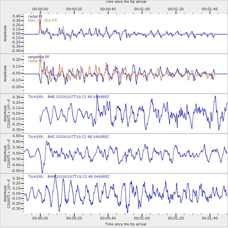
H16K Elim, AK, USA - Earthquake Result Viewer
*The percent match for this event was below the threshold and hence no stack was calculated.
| Earthquake location: |
New Britain Region, P.N.G. |
| Earthquake latitude/longitude: |
-5.2/151.2 |
| Earthquake time(UTC): |
2020/01/07 (007) 19:11:35 GMT |
| Earthquake Depth: |
117 km |
| Earthquake Magnitude: |
6.0 Mww |
| Earthquake Catalog/Contributor: |
NEIC PDE/us |
|
| Network: |
TA USArray Transportable Network (new EarthScope stations) |
| Station: |
H16K Elim, AK, USA |
| Lat/Lon: |
64.64 N/162.24 W |
| Elevation: |
216 m |
|
| Distance: |
77.6 deg |
| Az: |
18.661 deg |
| Baz: |
227.727 deg |
| Ray Param: |
$rayparam |
*The percent match for this event was below the threshold and hence was not used in the summary stack. |
|
| Radial Match: |
68.19624 % |
| Radial Bump: |
400 |
| Transverse Match: |
66.507675 % |
| Transverse Bump: |
400 |
| SOD ConfigId: |
20465011 |
| Insert Time: |
2020-01-21 19:22:41.926 +0000 |
| GWidth: |
2.5 |
| Max Bumps: |
400 |
| Tol: |
0.001 |
|
Signal To Noise
| Channel | StoN | STA | LTA |
| TA:H16K: :BHZ:20200107T19:22:48.049988Z | 3.250349 | 5.2833326E-7 | 1.6254663E-7 |
| TA:H16K: :BHN:20200107T19:22:48.049988Z | 1.2648398 | 1.1037481E-7 | 8.726387E-8 |
| TA:H16K: :BHE:20200107T19:22:48.049988Z | 1.5898503 | 1.5315592E-7 | 9.6333544E-8 |
| Arrivals |
| Ps | |
| PpPs | |
| PsPs/PpSs | |


