You are here: Home > Network List > TA - USArray Transportable Network (new EarthScope stations) Stations List
> Station I17K Unalakleet, AK, USA > Earthquake Result Viewer
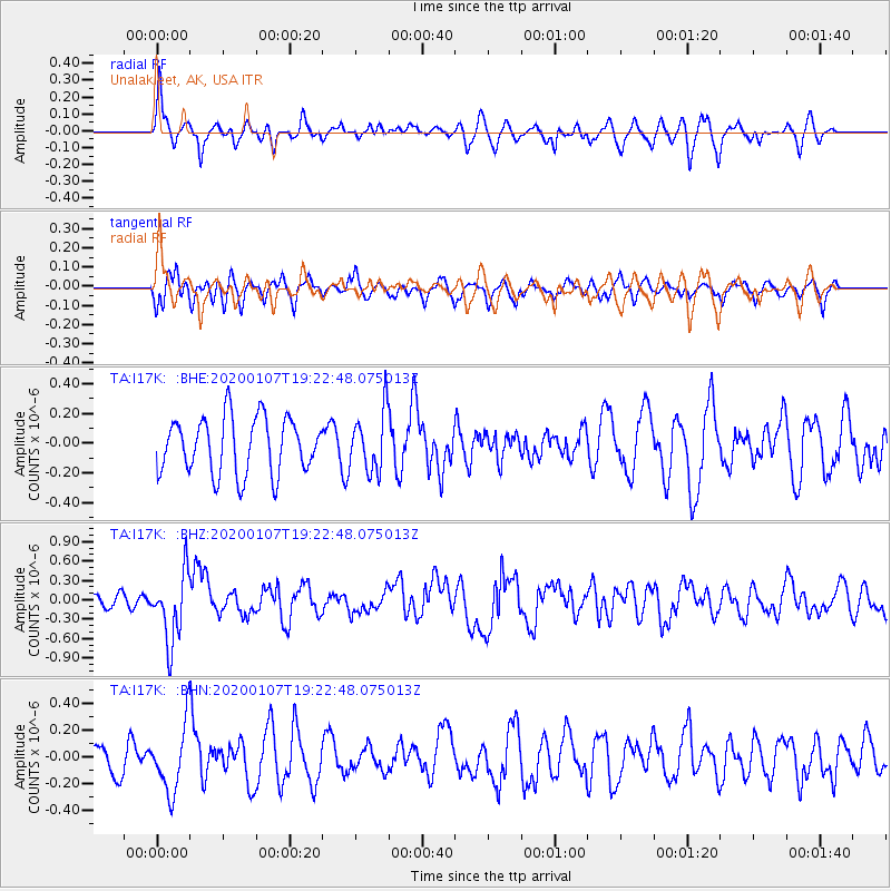
I17K Unalakleet, AK, USA - Earthquake Result Viewer
*The percent match for this event was below the threshold and hence no stack was calculated.
| Earthquake location: |
New Britain Region, P.N.G. |
| Earthquake latitude/longitude: |
-5.2/151.2 |
| Earthquake time(UTC): |
2020/01/07 (007) 19:11:35 GMT |
| Earthquake Depth: |
117 km |
| Earthquake Magnitude: |
6.0 Mww |
| Earthquake Catalog/Contributor: |
NEIC PDE/us |
|
| Network: |
TA USArray Transportable Network (new EarthScope stations) |
| Station: |
I17K Unalakleet, AK, USA |
| Lat/Lon: |
63.89 N/160.70 W |
| Elevation: |
105 m |
|
| Distance: |
77.6 deg |
| Az: |
19.697 deg |
| Baz: |
229.338 deg |
| Ray Param: |
$rayparam |
*The percent match for this event was below the threshold and hence was not used in the summary stack. |
|
| Radial Match: |
52.68774 % |
| Radial Bump: |
341 |
| Transverse Match: |
65.493126 % |
| Transverse Bump: |
400 |
| SOD ConfigId: |
20465011 |
| Insert Time: |
2020-01-21 19:22:49.246 +0000 |
| GWidth: |
2.5 |
| Max Bumps: |
400 |
| Tol: |
0.001 |
|
Signal To Noise
| Channel | StoN | STA | LTA |
| TA:I17K: :BHZ:20200107T19:22:48.075013Z | 3.020988 | 5.3512133E-7 | 1.7713454E-7 |
| TA:I17K: :BHN:20200107T19:22:48.075013Z | 1.6248931 | 2.473343E-7 | 1.5221573E-7 |
| TA:I17K: :BHE:20200107T19:22:48.075013Z | 1.0585755 | 1.991697E-7 | 1.8814879E-7 |
| Arrivals |
| Ps | |
| PpPs | |
| PsPs/PpSs | |


