You are here: Home > Network List > TA - USArray Transportable Network (new EarthScope stations) Stations List
> Station L15K Ungalak Mountain, AK, USA > Earthquake Result Viewer
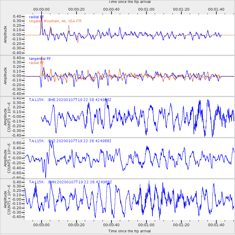
L15K Ungalak Mountain, AK, USA - Earthquake Result Viewer
*The percent match for this event was below the threshold and hence no stack was calculated.
| Earthquake location: |
New Britain Region, P.N.G. |
| Earthquake latitude/longitude: |
-5.2/151.2 |
| Earthquake time(UTC): |
2020/01/07 (007) 19:11:35 GMT |
| Earthquake Depth: |
117 km |
| Earthquake Magnitude: |
6.0 Mww |
| Earthquake Catalog/Contributor: |
NEIC PDE/us |
|
| Network: |
TA USArray Transportable Network (new EarthScope stations) |
| Station: |
L15K Ungalak Mountain, AK, USA |
| Lat/Lon: |
61.68 N/161.49 W |
| Elevation: |
219 m |
|
| Distance: |
75.9 deg |
| Az: |
21.175 deg |
| Baz: |
228.973 deg |
| Ray Param: |
$rayparam |
*The percent match for this event was below the threshold and hence was not used in the summary stack. |
|
| Radial Match: |
42.326626 % |
| Radial Bump: |
400 |
| Transverse Match: |
58.819088 % |
| Transverse Bump: |
400 |
| SOD ConfigId: |
20465011 |
| Insert Time: |
2020-01-21 19:23:07.382 +0000 |
| GWidth: |
2.5 |
| Max Bumps: |
400 |
| Tol: |
0.001 |
|
Signal To Noise
| Channel | StoN | STA | LTA |
| TA:L15K: :BHZ:20200107T19:22:38.424988Z | 2.4283988 | 3.3988428E-7 | 1.399623E-7 |
| TA:L15K: :BHN:20200107T19:22:38.424988Z | 0.93893003 | 1.3133932E-7 | 1.3988189E-7 |
| TA:L15K: :BHE:20200107T19:22:38.424988Z | 1.3917457 | 1.4729338E-7 | 1.05833536E-7 |
| Arrivals |
| Ps | |
| PpPs | |
| PsPs/PpSs | |


