You are here: Home > Network List > MN - MEDNET Project Stations List
> Station KEG Kottamya, Egypt > Earthquake Result Viewer
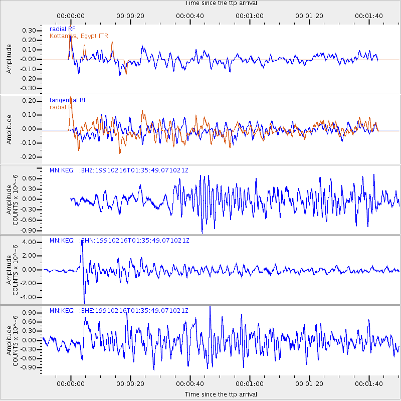
KEG Kottamya, Egypt - Earthquake Result Viewer
*The percent match for this event was below the threshold and hence no stack was calculated.
| Earthquake location: |
Kuril Islands |
| Earthquake latitude/longitude: |
48.2/154.4 |
| Earthquake time(UTC): |
1991/02/16 (047) 01:23:40 GMT |
| Earthquake Depth: |
44 km |
| Earthquake Magnitude: |
6.3 MB, 5.7 MS, 5.4 UNKNOWN |
| Earthquake Catalog/Contributor: |
WHDF/NEIC |
|
| Network: |
MN MEDNET Project |
| Station: |
KEG Kottamya, Egypt |
| Lat/Lon: |
29.93 N/31.83 E |
| Elevation: |
460 m |
|
| Distance: |
86.7 deg |
| Az: |
312.858 deg |
| Baz: |
34.382 deg |
| Ray Param: |
$rayparam |
*The percent match for this event was below the threshold and hence was not used in the summary stack. |
|
| Radial Match: |
74.24454 % |
| Radial Bump: |
400 |
| Transverse Match: |
76.76556 % |
| Transverse Bump: |
400 |
| SOD ConfigId: |
4480 |
| Insert Time: |
2010-03-08 17:16:18.075 +0000 |
| GWidth: |
2.5 |
| Max Bumps: |
400 |
| Tol: |
0.001 |
|
Signal To Noise
| Channel | StoN | STA | LTA |
| MN:KEG: :BHN:19910216T01:35:49.071021Z | 18.542534 | 1.8933225E-6 | 1.02106995E-7 |
| MN:KEG: :BHE:19910216T01:35:49.071021Z | 2.1192648 | 2.8933536E-7 | 1.3652628E-7 |
| MN:KEG: :BHZ:19910216T01:35:49.071021Z | 1.3970975 | 2.110331E-7 | 1.5105108E-7 |
| Arrivals |
| Ps | |
| PpPs | |
| PsPs/PpSs | |


