You are here: Home > Network List > DK - Danish Seismological Network Stations List
> Station ILULI Ilulissat, Greenland > Earthquake Result Viewer
ILULI Ilulissat, Greenland - Earthquake Result Viewer
| Earthquake location: |
Eastern Siberia, Russia |
| Earthquake latitude/longitude: |
62.3/171.1 |
| Earthquake time(UTC): |
2020/01/09 (009) 08:38:08 GMT |
| Earthquake Depth: |
10 km |
| Earthquake Magnitude: |
6.3 Mww |
| Earthquake Catalog/Contributor: |
NEIC PDE/us |
|
| Network: |
DK Danish Seismological Network |
| Station: |
ILULI Ilulissat, Greenland |
| Lat/Lon: |
69.21 N/51.10 W |
| Elevation: |
54 m |
|
| Distance: |
45.4 deg |
| Az: |
19.682 deg |
| Baz: |
333.88 deg |
| Ray Param: |
0.07133822 |
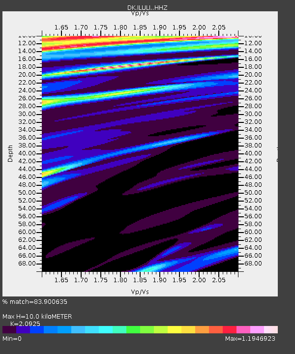
| Estimated Moho Depth: |
10.0 km |
| Estimated Crust Vp/Vs: |
2.09 |
| Assumed Crust Vp: |
6.459 km/s |
| Estimated Crust Vs: |
3.087 km/s |
| Estimated Crust Poisson's Ratio: |
0.35 |
|
| Radial Match: |
83.900635 % |
| Radial Bump: |
396 |
| Transverse Match: |
77.42628 % |
| Transverse Bump: |
400 |
| SOD ConfigId: |
20465011 |
| Insert Time: |
2020-01-23 08:43:45.499 +0000 |
| GWidth: |
2.5 |
| Max Bumps: |
400 |
| Tol: |
0.001 |
|

Signal To Noise
| Channel | StoN | STA | LTA |
| DK:ILULI: :HHZ:20200109T08:45:55.719992Z | 1.9462007 | 3.4016605E-6 | 1.7478468E-6 |
| DK:ILULI: :HHN:20200109T08:45:55.719992Z | 1.8573895 | 2.4050778E-6 | 1.29487E-6 |
| DK:ILULI: :HHE:20200109T08:45:55.719992Z | 1.613768 | 1.9557326E-6 | 1.2119045E-6 |
| Arrivals |
| Ps | 1.8 SECOND |
| PpPs | 4.5 SECOND |
| PsPs/PpSs | 6.3 SECOND |


