You are here: Home > Network List > TX - Texas Seismological Network Stations List
> Station FW03 Perrin-Whitt Elementary School > Earthquake Result Viewer
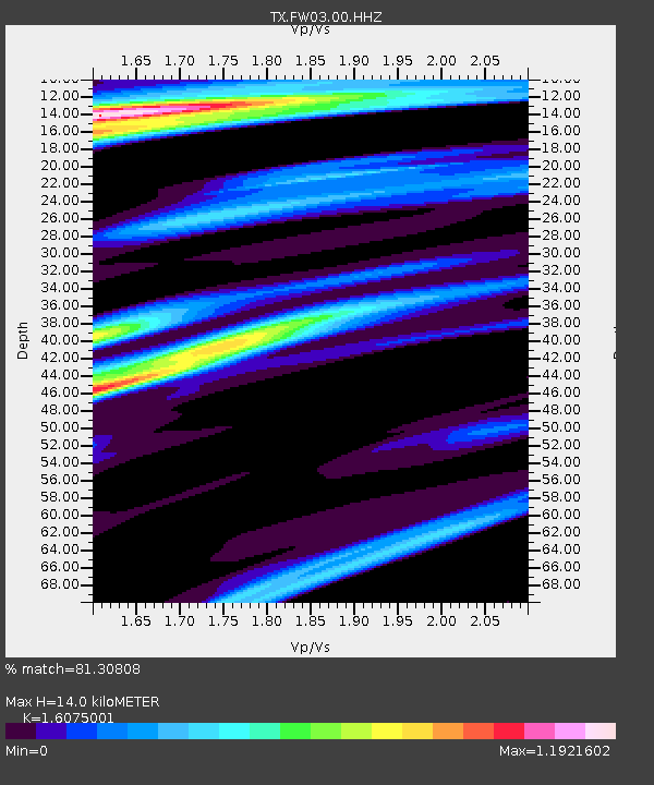
FW03 Perrin-Whitt Elementary School - Earthquake Result Viewer
| Earthquake location: |
Leeward Islands |
| Earthquake latitude/longitude: |
17.5/-61.1 |
| Earthquake time(UTC): |
2017/04/17 (107) 05:23:15 GMT |
| Earthquake Depth: |
21 km |
| Earthquake Magnitude: |
5.6 Mww |
| Earthquake Catalog/Contributor: |
NEIC PDE/us |
|
| Network: |
TX Texas Seismological Network |
| Station: |
FW03 Perrin-Whitt Elementary School |
| Lat/Lon: |
33.04 N/98.07 W |
| Elevation: |
322 m |
|
| Distance: |
36.6 deg |
| Az: |
302.176 deg |
| Baz: |
105.898 deg |
| Ray Param: |
0.07656528 |
| Estimated Moho Depth: |
14.0 km |
| Estimated Crust Vp/Vs: |
1.61 |
| Assumed Crust Vp: |
6.426 km/s |
| Estimated Crust Vs: |
3.998 km/s |
| Estimated Crust Poisson's Ratio: |
0.18 |
|
| Radial Match: |
81.30808 % |
| Radial Bump: |
337 |
| Transverse Match: |
73.33963 % |
| Transverse Bump: |
400 |
| SOD ConfigId: |
2028011 |
| Insert Time: |
2017-05-01 05:28:56.334 +0000 |
| GWidth: |
2.5 |
| Max Bumps: |
400 |
| Tol: |
0.001 |
|

Signal To Noise
| Channel | StoN | STA | LTA |
| TX:FW03:00:HHZ:20170417T05:29:49.459987Z | 6.38295 | 6.144174E-7 | 9.625916E-8 |
| TX:FW03:00:HH1:20170417T05:29:49.459987Z | 1.5810419 | 1.2912366E-7 | 8.166998E-8 |
| TX:FW03:00:HH2:20170417T05:29:49.459987Z | 3.1553478 | 2.857948E-7 | 9.0574744E-8 |
| Arrivals |
| Ps | 1.4 SECOND |
| PpPs | 5.2 SECOND |
| PsPs/PpSs | 6.7 SECOND |


