You are here: Home > Network List > TS - TERRAscope (Southern California Seismic Network) Stations List
> Station PAS Pasadena, California, USA > Earthquake Result Viewer
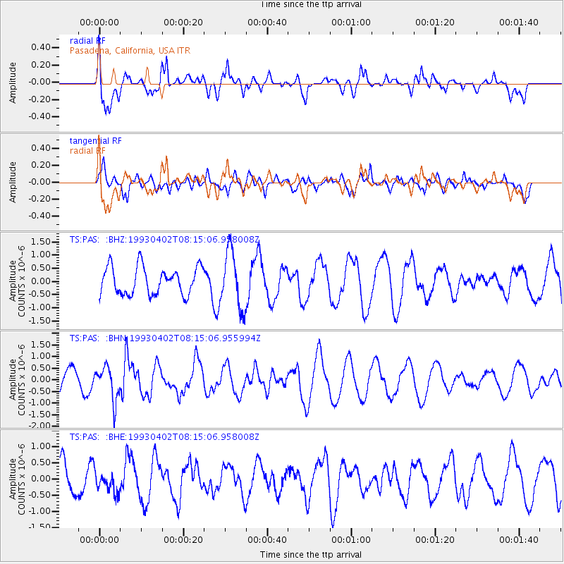
PAS Pasadena, California, USA - Earthquake Result Viewer
*The percent match for this event was below the threshold and hence no stack was calculated.
| Earthquake location: |
Tonga Islands Region |
| Earthquake latitude/longitude: |
-17.4/-171.9 |
| Earthquake time(UTC): |
1993/04/02 (092) 08:04:15 GMT |
| Earthquake Depth: |
33 km |
| Earthquake Magnitude: |
5.8 MB, 5.6 MS |
| Earthquake Catalog/Contributor: |
WHDF/NEIC |
|
| Network: |
TS TERRAscope (Southern California Seismic Network) |
| Station: |
PAS Pasadena, California, USA |
| Lat/Lon: |
34.15 N/118.17 W |
| Elevation: |
295 m |
|
| Distance: |
72.4 deg |
| Az: |
44.568 deg |
| Baz: |
233.902 deg |
| Ray Param: |
$rayparam |
*The percent match for this event was below the threshold and hence was not used in the summary stack. |
|
| Radial Match: |
59.55285 % |
| Radial Bump: |
400 |
| Transverse Match: |
54.63911 % |
| Transverse Bump: |
400 |
| SOD ConfigId: |
4480 |
| Insert Time: |
2010-02-26 14:39:22.305 +0000 |
| GWidth: |
2.5 |
| Max Bumps: |
400 |
| Tol: |
0.001 |
|
Signal To Noise
| Channel | StoN | STA | LTA |
| TS:PAS: :BHN:19930402T08:15:06.955994Z | 1.5663128 | 7.3912787E-7 | 4.718903E-7 |
| TS:PAS: :BHE:19930402T08:15:06.958008Z | 0.6877318 | 3.1145115E-7 | 4.5286717E-7 |
| TS:PAS: :BHZ:19930402T08:15:06.958008Z | 2.0915747 | 1.0861506E-6 | 5.19298E-7 |
| Arrivals |
| Ps | |
| PpPs | |
| PsPs/PpSs | |


