You are here: Home > Network List > MN - MEDNET Project Stations List
> Station MDT Midelt, Morocco > Earthquake Result Viewer
MDT Midelt, Morocco - Earthquake Result Viewer
| Earthquake location: |
Lake Tanganyika Region |
| Earthquake latitude/longitude: |
-7.4/30.4 |
| Earthquake time(UTC): |
1997/09/21 (264) 18:13:22 GMT |
| Earthquake Depth: |
10 km |
| Earthquake Magnitude: |
5.7 MB, 6.2 MS, 6.0 UNKNOWN, 5.9 MW |
| Earthquake Catalog/Contributor: |
WHDF/NEIC |
|
| Network: |
MN MEDNET Project |
| Station: |
MDT Midelt, Morocco |
| Lat/Lon: |
32.82 N/4.61 W |
| Elevation: |
1200 m |
|
| Distance: |
52.0 deg |
| Az: |
322.217 deg |
| Baz: |
133.808 deg |
| Ray Param: |
0.06704266 |
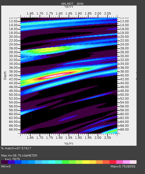
| Estimated Moho Depth: |
39.75 km |
| Estimated Crust Vp/Vs: |
1.79 |
| Assumed Crust Vp: |
6.65 km/s |
| Estimated Crust Vs: |
3.72 km/s |
| Estimated Crust Poisson's Ratio: |
0.27 |
|
| Radial Match: |
87.57417 % |
| Radial Bump: |
400 |
| Transverse Match: |
78.78772 % |
| Transverse Bump: |
400 |
| SOD ConfigId: |
6273 |
| Insert Time: |
2010-03-08 17:18:26.189 +0000 |
| GWidth: |
2.5 |
| Max Bumps: |
400 |
| Tol: |
0.001 |
|

Signal To Noise
| Channel | StoN | STA | LTA |
| MN:MDT: :BHN:19970921T18:22:01.121997Z | 2.0503106 | 1.0248519E-7 | 4.9985204E-8 |
| MN:MDT: :BHE:19970921T18:22:01.121997Z | 2.2108743 | 1.02262575E-7 | 4.6254357E-8 |
| MN:MDT: :BHZ:19970921T18:22:01.121997Z | 3.293726 | 2.5457237E-7 | 7.729009E-8 |
| Arrivals |
| Ps | 5.0 SECOND |
| PpPs | 16 SECOND |
| PsPs/PpSs | 21 SECOND |


