You are here: Home > Network List > IU - Global Seismograph Network (GSN - IRIS/USGS) Stations List
> Station RSSD Black Hills, South Dakota, USA > Earthquake Result Viewer
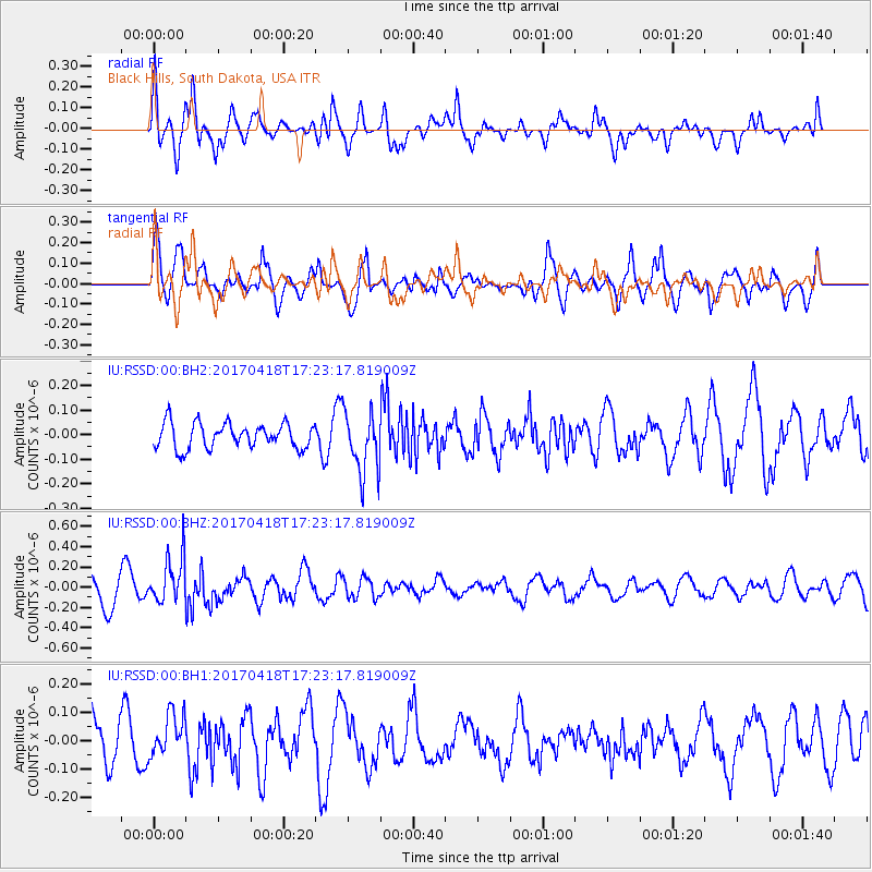
RSSD Black Hills, South Dakota, USA - Earthquake Result Viewer
*The percent match for this event was below the threshold and hence no stack was calculated.
| Earthquake location: |
Fiji Islands Region |
| Earthquake latitude/longitude: |
-18.1/-178.4 |
| Earthquake time(UTC): |
2017/04/18 (108) 17:11:47 GMT |
| Earthquake Depth: |
626 km |
| Earthquake Magnitude: |
6.0 Mww |
| Earthquake Catalog/Contributor: |
NEIC PDE/us |
|
| Network: |
IU Global Seismograph Network (GSN - IRIS/USGS) |
| Station: |
RSSD Black Hills, South Dakota, USA |
| Lat/Lon: |
44.12 N/104.04 W |
| Elevation: |
2090 m |
|
| Distance: |
91.7 deg |
| Az: |
43.934 deg |
| Baz: |
246.427 deg |
| Ray Param: |
$rayparam |
*The percent match for this event was below the threshold and hence was not used in the summary stack. |
|
| Radial Match: |
71.482605 % |
| Radial Bump: |
400 |
| Transverse Match: |
61.83137 % |
| Transverse Bump: |
393 |
| SOD ConfigId: |
2028011 |
| Insert Time: |
2017-05-02 17:16:39.674 +0000 |
| GWidth: |
2.5 |
| Max Bumps: |
400 |
| Tol: |
0.001 |
|
Signal To Noise
| Channel | StoN | STA | LTA |
| IU:RSSD:00:BHZ:20170418T17:23:17.819009Z | 2.2377586 | 2.321676E-7 | 1.0375006E-7 |
| IU:RSSD:00:BH1:20170418T17:23:17.819009Z | 0.5478996 | 7.656038E-8 | 1.3973433E-7 |
| IU:RSSD:00:BH2:20170418T17:23:17.819009Z | 2.4528499 | 1.2417901E-7 | 5.062642E-8 |
| Arrivals |
| Ps | |
| PpPs | |
| PsPs/PpSs | |


