You are here: Home > Network List > N4 - Central and EAstern US Network Stations List
> Station Z35B Perchaven, Sanger, TX, USA > Earthquake Result Viewer
Z35B Perchaven, Sanger, TX, USA - Earthquake Result Viewer
| Earthquake location: |
Puerto Rico Region |
| Earthquake latitude/longitude: |
17.9/-66.8 |
| Earthquake time(UTC): |
2020/01/11 (011) 12:54:44 GMT |
| Earthquake Depth: |
5.0 km |
| Earthquake Magnitude: |
6.0 Mi |
| Earthquake Catalog/Contributor: |
NEIC PDE/pt |
|
| Network: |
N4 Central and EAstern US Network |
| Station: |
Z35B Perchaven, Sanger, TX, USA |
| Lat/Lon: |
33.33 N/97.25 W |
| Elevation: |
234 m |
|
| Distance: |
31.3 deg |
| Az: |
305.341 deg |
| Baz: |
111.884 deg |
| Ray Param: |
0.079126984 |
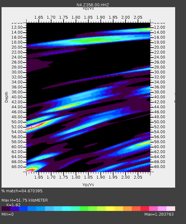
| Estimated Moho Depth: |
51.75 km |
| Estimated Crust Vp/Vs: |
1.62 |
| Assumed Crust Vp: |
6.38 km/s |
| Estimated Crust Vs: |
3.939 km/s |
| Estimated Crust Poisson's Ratio: |
0.19 |
|
| Radial Match: |
84.670395 % |
| Radial Bump: |
400 |
| Transverse Match: |
60.44231 % |
| Transverse Bump: |
400 |
| SOD ConfigId: |
20465011 |
| Insert Time: |
2020-01-25 13:05:03.490 +0000 |
| GWidth: |
2.5 |
| Max Bumps: |
400 |
| Tol: |
0.001 |
|

Signal To Noise
| Channel | StoN | STA | LTA |
| N4:Z35B:00:HHZ:20200111T13:00:34.48999Z | 4.208757 | 8.039801E-7 | 1.9102553E-7 |
| N4:Z35B:00:HH1:20200111T13:00:34.48999Z | 1.4539245 | 3.188355E-7 | 2.1929301E-7 |
| N4:Z35B:00:HH2:20200111T13:00:34.48999Z | 3.2553754 | 8.0354295E-7 | 2.4683573E-7 |
| Arrivals |
| Ps | 5.5 SECOND |
| PpPs | 19 SECOND |
| PsPs/PpSs | 25 SECOND |


