You are here: Home > Network List > TA - USArray Transportable Network (new EarthScope stations) Stations List
> Station D23K Nanushuk River, AK USA > Earthquake Result Viewer
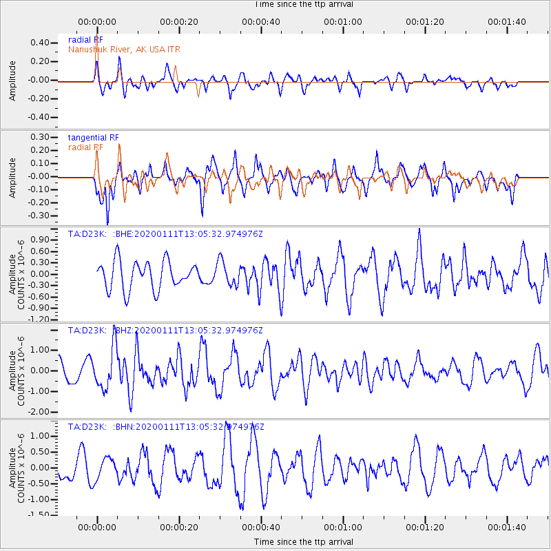
D23K Nanushuk River, AK USA - Earthquake Result Viewer
*The percent match for this event was below the threshold and hence no stack was calculated.
| Earthquake location: |
Puerto Rico Region |
| Earthquake latitude/longitude: |
17.9/-66.8 |
| Earthquake time(UTC): |
2020/01/11 (011) 12:54:44 GMT |
| Earthquake Depth: |
5.0 km |
| Earthquake Magnitude: |
6.0 Mi |
| Earthquake Catalog/Contributor: |
NEIC PDE/pt |
|
| Network: |
TA USArray Transportable Network (new EarthScope stations) |
| Station: |
D23K Nanushuk River, AK USA |
| Lat/Lon: |
68.97 N/150.68 W |
| Elevation: |
406 m |
|
| Distance: |
71.3 deg |
| Az: |
337.726 deg |
| Baz: |
89.084 deg |
| Ray Param: |
$rayparam |
*The percent match for this event was below the threshold and hence was not used in the summary stack. |
|
| Radial Match: |
56.84593 % |
| Radial Bump: |
400 |
| Transverse Match: |
65.11974 % |
| Transverse Bump: |
400 |
| SOD ConfigId: |
20465011 |
| Insert Time: |
2020-01-25 13:08:50.507 +0000 |
| GWidth: |
2.5 |
| Max Bumps: |
400 |
| Tol: |
0.001 |
|
Signal To Noise
| Channel | StoN | STA | LTA |
| TA:D23K: :BHZ:20200111T13:05:32.974976Z | 2.7028184 | 1.0475406E-6 | 3.8757344E-7 |
| TA:D23K: :BHN:20200111T13:05:32.974976Z | 1.0083069 | 3.2934298E-7 | 3.266297E-7 |
| TA:D23K: :BHE:20200111T13:05:32.974976Z | 0.8808051 | 3.2471868E-7 | 3.6866123E-7 |
| Arrivals |
| Ps | |
| PpPs | |
| PsPs/PpSs | |


