You are here: Home > Network List > TA - USArray Transportable Network (new EarthScope stations) Stations List
> Station G21K Allakaket, AK, USA > Earthquake Result Viewer
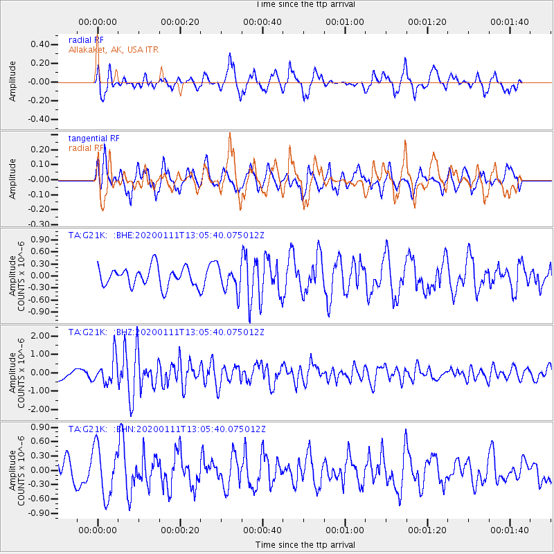
G21K Allakaket, AK, USA - Earthquake Result Viewer
*The percent match for this event was below the threshold and hence no stack was calculated.
| Earthquake location: |
Puerto Rico Region |
| Earthquake latitude/longitude: |
17.9/-66.8 |
| Earthquake time(UTC): |
2020/01/11 (011) 12:54:44 GMT |
| Earthquake Depth: |
5.0 km |
| Earthquake Magnitude: |
6.0 Mi |
| Earthquake Catalog/Contributor: |
NEIC PDE/pt |
|
| Network: |
TA USArray Transportable Network (new EarthScope stations) |
| Station: |
G21K Allakaket, AK, USA |
| Lat/Lon: |
66.52 N/153.51 W |
| Elevation: |
446 m |
|
| Distance: |
72.5 deg |
| Az: |
335.19 deg |
| Baz: |
85.682 deg |
| Ray Param: |
$rayparam |
*The percent match for this event was below the threshold and hence was not used in the summary stack. |
|
| Radial Match: |
72.7142 % |
| Radial Bump: |
400 |
| Transverse Match: |
44.783596 % |
| Transverse Bump: |
400 |
| SOD ConfigId: |
20465011 |
| Insert Time: |
2020-01-25 13:09:13.505 +0000 |
| GWidth: |
2.5 |
| Max Bumps: |
400 |
| Tol: |
0.001 |
|
Signal To Noise
| Channel | StoN | STA | LTA |
| TA:G21K: :BHZ:20200111T13:05:40.075012Z | 2.486508 | 7.3620095E-7 | 2.960783E-7 |
| TA:G21K: :BHN:20200111T13:05:40.075012Z | 1.5772533 | 5.331286E-7 | 3.3801078E-7 |
| TA:G21K: :BHE:20200111T13:05:40.075012Z | 1.3055477 | 3.0876393E-7 | 2.3650144E-7 |
| Arrivals |
| Ps | |
| PpPs | |
| PsPs/PpSs | |


