You are here: Home > Network List > TX - Texas Seismological Network Stations List
> Station PLPT Palo Pinto > Earthquake Result Viewer
PLPT Palo Pinto - Earthquake Result Viewer
| Earthquake location: |
Puerto Rico Region |
| Earthquake latitude/longitude: |
17.9/-66.8 |
| Earthquake time(UTC): |
2020/01/11 (011) 12:54:44 GMT |
| Earthquake Depth: |
5.0 km |
| Earthquake Magnitude: |
6.0 Mi |
| Earthquake Catalog/Contributor: |
NEIC PDE/pt |
|
| Network: |
TX Texas Seismological Network |
| Station: |
PLPT Palo Pinto |
| Lat/Lon: |
32.81 N/98.32 W |
| Elevation: |
336 m |
|
| Distance: |
32.0 deg |
| Az: |
303.813 deg |
| Baz: |
110.006 deg |
| Ray Param: |
0.07887423 |
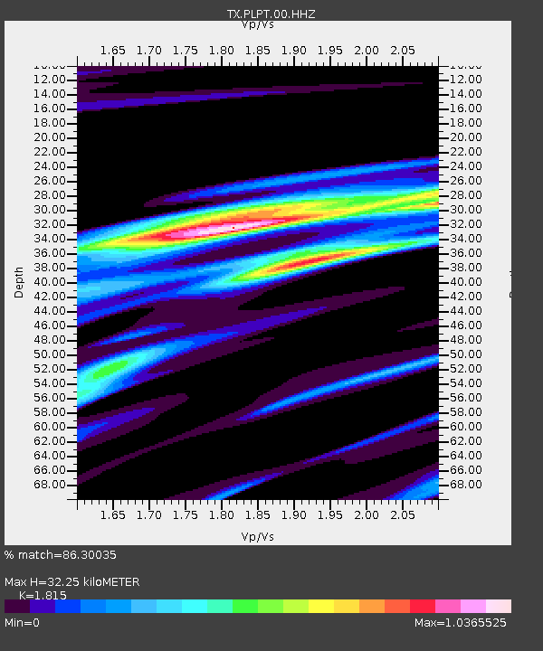
| Estimated Moho Depth: |
32.25 km |
| Estimated Crust Vp/Vs: |
1.82 |
| Assumed Crust Vp: |
6.426 km/s |
| Estimated Crust Vs: |
3.541 km/s |
| Estimated Crust Poisson's Ratio: |
0.28 |
|
| Radial Match: |
86.30035 % |
| Radial Bump: |
266 |
| Transverse Match: |
66.18748 % |
| Transverse Bump: |
400 |
| SOD ConfigId: |
20465011 |
| Insert Time: |
2020-01-25 13:10:34.981 +0000 |
| GWidth: |
2.5 |
| Max Bumps: |
400 |
| Tol: |
0.001 |
|

Signal To Noise
| Channel | StoN | STA | LTA |
| TX:PLPT:00:HHZ:20200111T13:00:40.174988Z | 3.0738056 | 6.6822207E-7 | 2.1739244E-7 |
| TX:PLPT:00:HH1:20200111T13:00:40.174988Z | 2.3751488 | 3.564271E-7 | 1.5006518E-7 |
| TX:PLPT:00:HH2:20200111T13:00:40.174988Z | 0.95629793 | 2.062856E-7 | 2.1571269E-7 |
| Arrivals |
| Ps | 4.4 SECOND |
| PpPs | 13 SECOND |
| PsPs/PpSs | 17 SECOND |


