You are here: Home > Network List > TA - USArray Transportable Network (new EarthScope stations) Stations List
> Station R33M Jennings River, BC, CAN > Earthquake Result Viewer
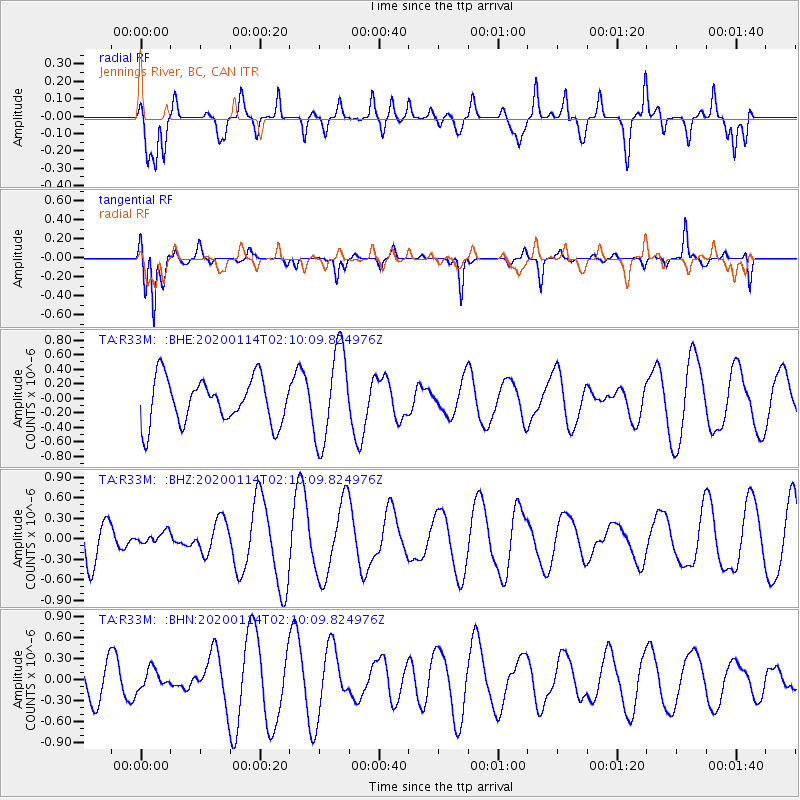
R33M Jennings River, BC, CAN - Earthquake Result Viewer
*The percent match for this event was below the threshold and hence no stack was calculated.
| Earthquake location: |
Chile-Bolivia Border Region |
| Earthquake latitude/longitude: |
-21.8/-68.3 |
| Earthquake time(UTC): |
2020/01/14 (014) 01:57:28 GMT |
| Earthquake Depth: |
115 km |
| Earthquake Magnitude: |
5.1 Mwr |
| Earthquake Catalog/Contributor: |
NEIC PDE/us |
|
| Network: |
TA USArray Transportable Network (new EarthScope stations) |
| Station: |
R33M Jennings River, BC, CAN |
| Lat/Lon: |
59.39 N/130.97 W |
| Elevation: |
1437 m |
|
| Distance: |
95.6 deg |
| Az: |
332.826 deg |
| Baz: |
123.924 deg |
| Ray Param: |
$rayparam |
*The percent match for this event was below the threshold and hence was not used in the summary stack. |
|
| Radial Match: |
65.86233 % |
| Radial Bump: |
400 |
| Transverse Match: |
81.35531 % |
| Transverse Bump: |
287 |
| SOD ConfigId: |
20465011 |
| Insert Time: |
2020-01-28 02:07:59.380 +0000 |
| GWidth: |
2.5 |
| Max Bumps: |
400 |
| Tol: |
0.001 |
|
Signal To Noise
| Channel | StoN | STA | LTA |
| TA:R33M: :BHZ:20200114T02:10:09.824976Z | 0.35036588 | 8.64365E-8 | 2.4670354E-7 |
| TA:R33M: :BHN:20200114T02:10:09.824976Z | 0.53316617 | 1.4070874E-7 | 2.639116E-7 |
| TA:R33M: :BHE:20200114T02:10:09.824976Z | 2.0717854 | 6.4048555E-7 | 3.0914666E-7 |
| Arrivals |
| Ps | |
| PpPs | |
| PsPs/PpSs | |


