You are here: Home > Network List > TA - USArray Transportable Network (new EarthScope stations) Stations List
> Station A22K Sinclair Lake, AK, USA > Earthquake Result Viewer
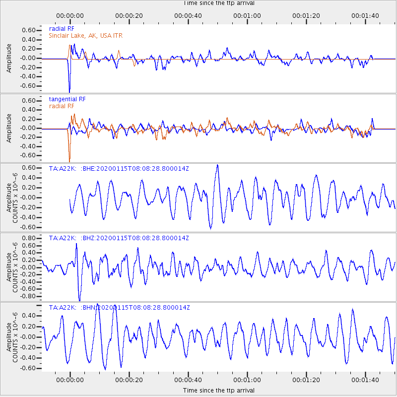
A22K Sinclair Lake, AK, USA - Earthquake Result Viewer
*The percent match for this event was below the threshold and hence no stack was calculated.
| Earthquake location: |
Timor Region |
| Earthquake latitude/longitude: |
-10.4/124.1 |
| Earthquake time(UTC): |
2020/01/15 (015) 07:55:29 GMT |
| Earthquake Depth: |
10 km |
| Earthquake Magnitude: |
5.5 Mww |
| Earthquake Catalog/Contributor: |
NEIC PDE/us |
|
| Network: |
TA USArray Transportable Network (new EarthScope stations) |
| Station: |
A22K Sinclair Lake, AK, USA |
| Lat/Lon: |
71.00 N/154.97 W |
| Elevation: |
6.0 m |
|
| Distance: |
96.8 deg |
| Az: |
19.006 deg |
| Baz: |
258.075 deg |
| Ray Param: |
$rayparam |
*The percent match for this event was below the threshold and hence was not used in the summary stack. |
|
| Radial Match: |
51.005173 % |
| Radial Bump: |
400 |
| Transverse Match: |
32.84191 % |
| Transverse Bump: |
400 |
| SOD ConfigId: |
20465011 |
| Insert Time: |
2020-01-29 08:00:36.578 +0000 |
| GWidth: |
2.5 |
| Max Bumps: |
400 |
| Tol: |
0.001 |
|
Signal To Noise
| Channel | StoN | STA | LTA |
| TA:A22K: :BHZ:20200115T08:08:28.800014Z | 2.2232256 | 4.037306E-7 | 1.8159679E-7 |
| TA:A22K: :BHN:20200115T08:08:28.800014Z | 1.0777767 | 2.751878E-7 | 2.5532916E-7 |
| TA:A22K: :BHE:20200115T08:08:28.800014Z | 0.8036761 | 1.7092201E-7 | 2.1267523E-7 |
| Arrivals |
| Ps | |
| PpPs | |
| PsPs/PpSs | |


