You are here: Home > Network List > MN - MEDNET Project Stations List
> Station RTC Rabat, Morocco > Earthquake Result Viewer
RTC Rabat, Morocco - Earthquake Result Viewer

| Earthquake location: |
East Of Kuril Islands |
| Earthquake latitude/longitude: |
46.9/155.2 |
| Earthquake time(UTC): |
2009/01/15 (015) 17:49:39 GMT |
| Earthquake Depth: |
36 km |
| Earthquake Magnitude: |
6.9 MB, 7.5 MS, 7.4 MW, 7.4 MW |
| Earthquake Catalog/Contributor: |
WHDF/NEIC |
|
| Network: |
MN MEDNET Project |
| Station: |
RTC Rabat, Morocco |
| Lat/Lon: |
33.99 N/6.86 W |
| Elevation: |
50 m |
|
| Distance: |
97.9 deg |
| Az: |
344.985 deg |
| Baz: |
12.356 deg |
| Ray Param: |
0.040050037 |
| Estimated Moho Depth: |
35.75 km |
| Estimated Crust Vp/Vs: |
1.74 |
| Assumed Crust Vp: |
6.65 km/s |
| Estimated Crust Vs: |
3.827 km/s |
| Estimated Crust Poisson's Ratio: |
0.25 |
|
| Radial Match: |
96.34712 % |
| Radial Bump: |
400 |
| Transverse Match: |
78.72339 % |
| Transverse Bump: |
400 |
| SOD ConfigId: |
2834 |
| Insert Time: |
2010-03-08 17:19:50.990 +0000 |
| GWidth: |
2.5 |
| Max Bumps: |
400 |
| Tol: |
0.001 |
|
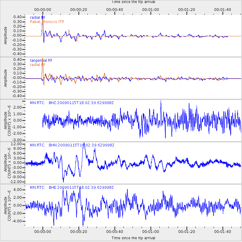
Signal To Noise
| Channel | StoN | STA | LTA |
| MN:RTC: :BHN:20090115T18:02:39.629998Z | 3.9759946 | 2.7626018E-6 | 6.948203E-7 |
| MN:RTC: :BHE:20090115T18:02:39.629998Z | 1.7542303 | 1.1573833E-6 | 6.5976707E-7 |
| MN:RTC: :BHZ:20090115T18:02:39.629998Z | 0.8471492 | 4.1722282E-7 | 4.925022E-7 |
| Arrivals |
| Ps | 4.0 SECOND |
| PpPs | 14 SECOND |
| PsPs/PpSs | 18 SECOND |


