You are here: Home > Network List > TJ - Tajikistan National Seismic Network Stations List
> Station MANEM Manem, Tajikistan > Earthquake Result Viewer
MANEM Manem, Tajikistan - Earthquake Result Viewer
| Earthquake location: |
Timor Region |
| Earthquake latitude/longitude: |
-10.4/124.1 |
| Earthquake time(UTC): |
2020/01/15 (015) 07:55:29 GMT |
| Earthquake Depth: |
10 km |
| Earthquake Magnitude: |
5.5 Mww |
| Earthquake Catalog/Contributor: |
NEIC PDE/us |
|
| Network: |
TJ Tajikistan National Seismic Network |
| Station: |
MANEM Manem, Tajikistan |
| Lat/Lon: |
37.53 N/71.66 E |
| Elevation: |
2312 m |
|
| Distance: |
68.4 deg |
| Az: |
317.328 deg |
| Baz: |
122.987 deg |
| Ray Param: |
0.056332923 |
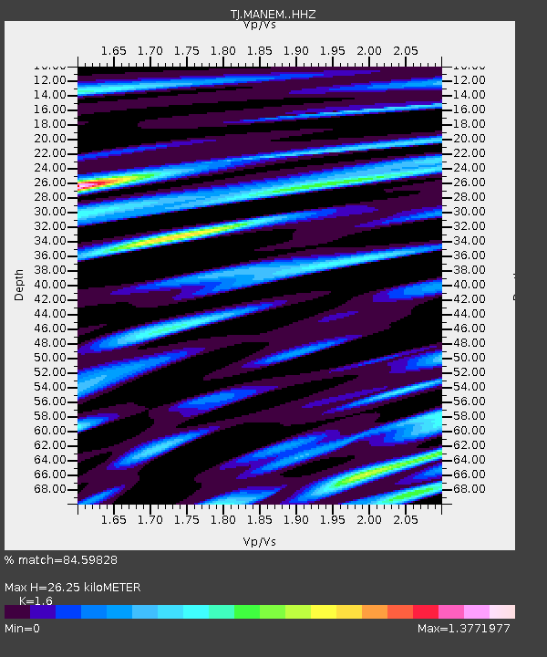
| Estimated Moho Depth: |
26.25 km |
| Estimated Crust Vp/Vs: |
1.60 |
| Assumed Crust Vp: |
6.306 km/s |
| Estimated Crust Vs: |
3.941 km/s |
| Estimated Crust Poisson's Ratio: |
0.18 |
|
| Radial Match: |
84.59828 % |
| Radial Bump: |
400 |
| Transverse Match: |
85.49996 % |
| Transverse Bump: |
400 |
| SOD ConfigId: |
20465011 |
| Insert Time: |
2020-01-29 08:01:32.729 +0000 |
| GWidth: |
2.5 |
| Max Bumps: |
400 |
| Tol: |
0.001 |
|

Signal To Noise
| Channel | StoN | STA | LTA |
| TJ:MANEM: :HHZ:20200115T08:06:00.190028Z | 17.937845 | 3.3487247E-6 | 1.866849E-7 |
| TJ:MANEM: :HHN:20200115T08:06:00.190028Z | 4.9431996 | 5.8094963E-7 | 1.1752501E-7 |
| TJ:MANEM: :HHE:20200115T08:06:00.190028Z | 7.4043264 | 8.205441E-7 | 1.1081954E-7 |
| Arrivals |
| Ps | 2.6 SECOND |
| PpPs | 10 SECOND |
| PsPs/PpSs | 13 SECOND |


