You are here: Home > Network List > AG - Arkansas Seismic Network Stations List
> Station LCAR Lake Charles,AR > Earthquake Result Viewer
LCAR Lake Charles,AR - Earthquake Result Viewer
| Earthquake location: |
Peru-Ecuador Border Region |
| Earthquake latitude/longitude: |
-2.7/-75.3 |
| Earthquake time(UTC): |
2017/04/18 (108) 17:49:55 GMT |
| Earthquake Depth: |
11 km |
| Earthquake Magnitude: |
6.0 Mww |
| Earthquake Catalog/Contributor: |
NEIC PDE/us |
|
| Network: |
AG Arkansas Seismic Network |
| Station: |
LCAR Lake Charles,AR |
| Lat/Lon: |
36.07 N/91.15 W |
| Elevation: |
103 m |
|
| Distance: |
41.3 deg |
| Az: |
340.429 deg |
| Baz: |
155.607 deg |
| Ray Param: |
0.07385161 |
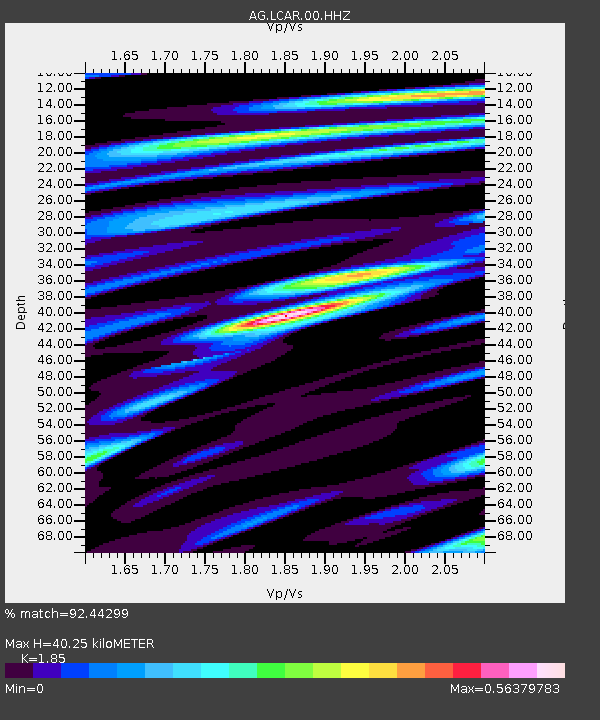
| Estimated Moho Depth: |
40.25 km |
| Estimated Crust Vp/Vs: |
1.85 |
| Assumed Crust Vp: |
6.53 km/s |
| Estimated Crust Vs: |
3.53 km/s |
| Estimated Crust Poisson's Ratio: |
0.29 |
|
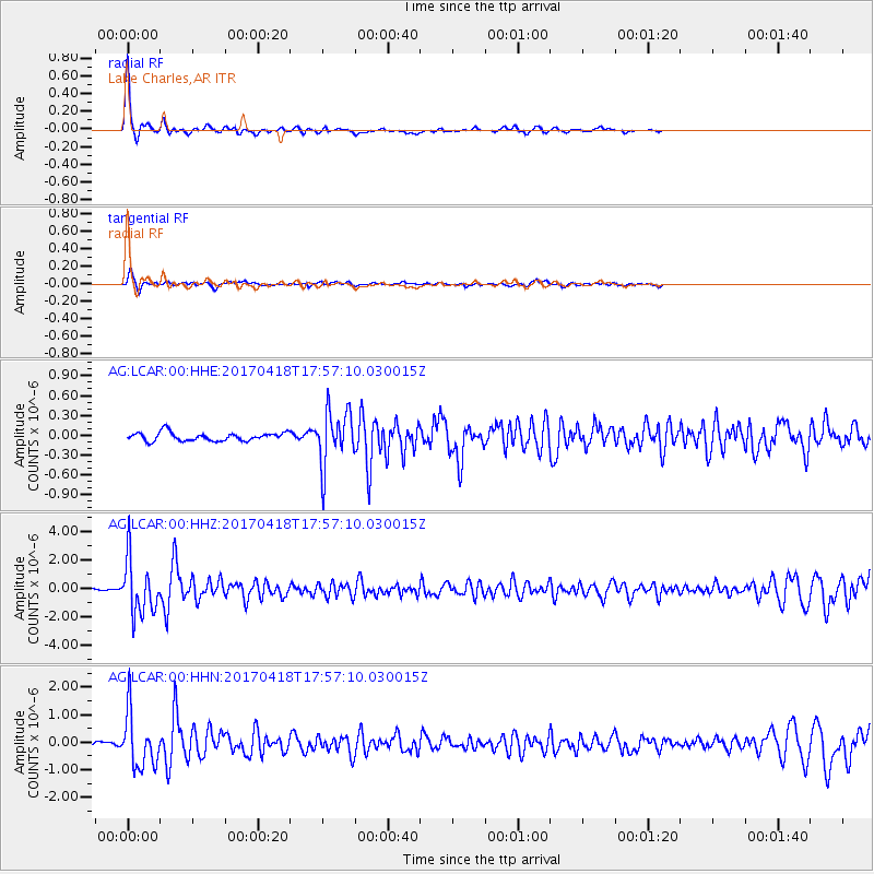
| Radial Match: |
92.44299 % |
| Radial Bump: |
254 |
| Transverse Match: |
75.61552 % |
| Transverse Bump: |
394 |
| SOD ConfigId: |
2028011 |
| Insert Time: |
2017-05-02 17:50:13.258 +0000 |
| GWidth: |
2.5 |
| Max Bumps: |
400 |
| Tol: |
0.001 |
|
Signal To Noise
| Channel | StoN | STA | LTA |
| AG:LCAR:00:HHZ:20170418T17:57:10.030015Z | 28.977797 | 1.9221961E-6 | 6.633341E-8 |
| AG:LCAR:00:HHN:20170418T17:57:10.030015Z | 10.826515 | 9.928532E-7 | 9.17057E-8 |
| AG:LCAR:00:HHE:20170418T17:57:10.030015Z | 6.394142 | 4.086249E-7 | 6.3906135E-8 |
| Arrivals |
| Ps | 5.6 SECOND |
| PpPs | 16 SECOND |
| PsPs/PpSs | 22 SECOND |


