You are here: Home > Network List > MN - MEDNET Project Stations List
> Station TIP Timpagrande, Italy > Earthquake Result Viewer
TIP Timpagrande, Italy - Earthquake Result Viewer
| Earthquake location: |
Southern Sumatra, Indonesia |
| Earthquake latitude/longitude: |
-5.0/103.0 |
| Earthquake time(UTC): |
2009/06/20 (171) 09:21:23 GMT |
| Earthquake Depth: |
46 km |
| Earthquake Magnitude: |
5.8 MB, 5.4 MW, 5.4 MW |
| Earthquake Catalog/Contributor: |
WHDF/NEIC |
|
| Network: |
MN MEDNET Project |
| Station: |
TIP Timpagrande, Italy |
| Lat/Lon: |
39.18 N/16.76 E |
| Elevation: |
789 m |
|
| Distance: |
90.2 deg |
| Az: |
309.138 deg |
| Baz: |
96.183 deg |
| Ray Param: |
0.041680235 |
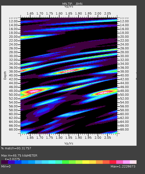
| Estimated Moho Depth: |
48.75 km |
| Estimated Crust Vp/Vs: |
2.03 |
| Assumed Crust Vp: |
6.1 km/s |
| Estimated Crust Vs: |
3.009 km/s |
| Estimated Crust Poisson's Ratio: |
0.34 |
|
| Radial Match: |
80.31757 % |
| Radial Bump: |
400 |
| Transverse Match: |
71.7273 % |
| Transverse Bump: |
400 |
| SOD ConfigId: |
2648 |
| Insert Time: |
2010-03-08 17:20:22.555 +0000 |
| GWidth: |
2.5 |
| Max Bumps: |
400 |
| Tol: |
0.001 |
|
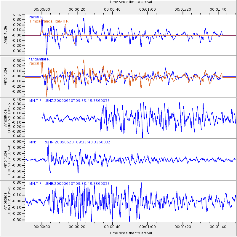
Signal To Noise
| Channel | StoN | STA | LTA |
| MN:TIP: :BHN:20090620T09:33:48.336003Z | 6.2141595 | 3.0485322E-7 | 4.9057835E-8 |
| MN:TIP: :BHE:20090620T09:33:48.336003Z | 1.6159465 | 4.9451696E-8 | 3.060231E-8 |
| MN:TIP: :BHZ:20090620T09:33:48.336003Z | 2.7204726 | 1.0735989E-7 | 3.946369E-8 |
| Arrivals |
| Ps | 8.3 SECOND |
| PpPs | 24 SECOND |
| PsPs/PpSs | 32 SECOND |


