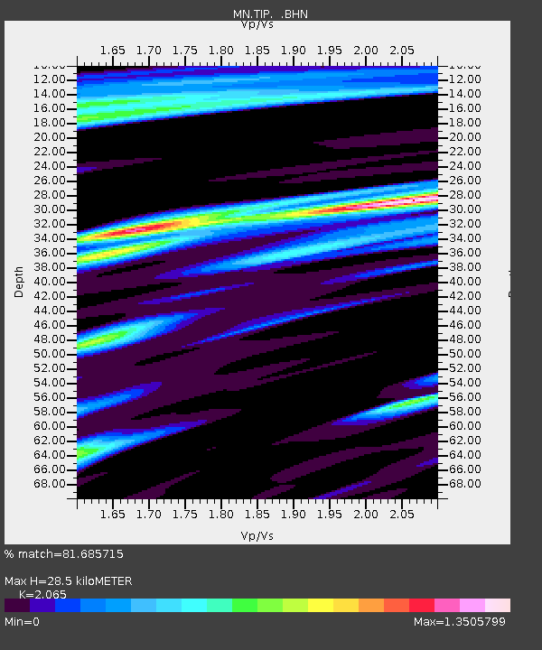
TIP Timpagrande, Italy - Earthquake Result Viewer
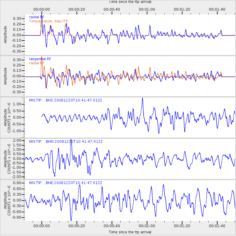
Earthquake location: Off East Coast Of Honshu, Japan
Earthquake latitude/longitude: 36.5/142.4
Earthquake time(UTC): 2008/12/20 (355) 10:29:23 GMT
Earthquake Depth: 19 km
Earthquake Magnitude: 6.0 MB, 6.3 MS, 6.3 MW, 6.3 MW
Earthquake Catalog/Contributor: WHDF/NEIC
Network: MN MEDNET Project
Station: TIP Timpagrande, Italy
Lat/Lon: 39.18 N/16.76 E
Elevation: 789 m
Distance: 89.5 deg
Az: 320.841 deg
Baz: 40.866 deg
Ray Param: 0.041761
Estimated Moho Depth: 28.5 km
Estimated Crust Vp/Vs: 2.07
Assumed Crust Vp: 6.1 km/s
Estimated Crust Vs: 2.954 km/s
Estimated Crust Poisson's Ratio: 0.35
Radial Match: 81.685715 %
Radial Bump: 400
Transverse Match: 71.836685 %
Transverse Bump: 400
SOD ConfigId: 2658
Insert Time: 2010-03-08 17:20:23.616 +0000
GWidth: 2.5
Max Bumps: 400
Tol: 0.001

Signal To Noise

ChannelStoNSTALTA
MN:TIP: :BHN:20081220T10:41:47.613Z2.89571054.391342E-71.516499E-7
MN:TIP: :BHE:20081220T10:41:47.613Z0.41020347.7954084E-81.9003764E-7
MN:TIP: :BHZ:20081220T10:41:47.613Z1.11496421.892022E-71.6969352E-7
Arrivals
Ps5.1 SECOND
PpPs14 SECOND
PsPs/PpSs19 SECOND