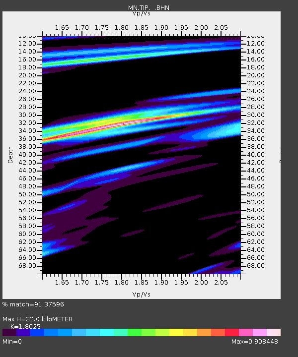
TIP Timpagrande, Italy - Earthquake Result Viewer

Earthquake location: Southeast Of Ryukyu Islands
Earthquake latitude/longitude: 24.9/128.0
Earthquake time(UTC): 2009/07/06 (187) 22:35:05 GMT
Earthquake Depth: 10 km
Earthquake Magnitude: 6.1 MB, 5.3 MS, 5.7 MW, 5.7 MW
Earthquake Catalog/Contributor: WHDF/NEIC
Network: MN MEDNET Project
Station: TIP Timpagrande, Italy
Lat/Lon: 39.18 N/16.76 E
Elevation: 789 m
Distance: 89.6 deg
Az: 313.587 deg
Baz: 57.829 deg
Ray Param: 0.041737266
Estimated Moho Depth: 32.0 km
Estimated Crust Vp/Vs: 1.80
Assumed Crust Vp: 6.1 km/s
Estimated Crust Vs: 3.384 km/s
Estimated Crust Poisson's Ratio: 0.28
Radial Match: 91.37596 %
Radial Bump: 400
Transverse Match: 84.25352 %
Transverse Bump: 400
SOD ConfigId: 2648
Insert Time: 2010-03-08 17:20:24.668 +0000
GWidth: 2.5
Max Bumps: 400
Tol: 0.001

Signal To Noise

ChannelStoNSTALTA
MN:TIP: :BHN:20090706T22:47:31.186016Z18.0100946.0421894E-73.3548908E-8
MN:TIP: :BHE:20090706T22:47:31.186016Z2.68299378.743876E-83.259E-8
MN:TIP: :BHZ:20090706T22:47:31.186016Z6.6379711.8979449E-72.8592245E-8
Arrivals
Ps4.3 SECOND
PpPs14 SECOND
PsPs/PpSs19 SECOND