You are here: Home > Network List > AG - Arkansas Seismic Network Stations List
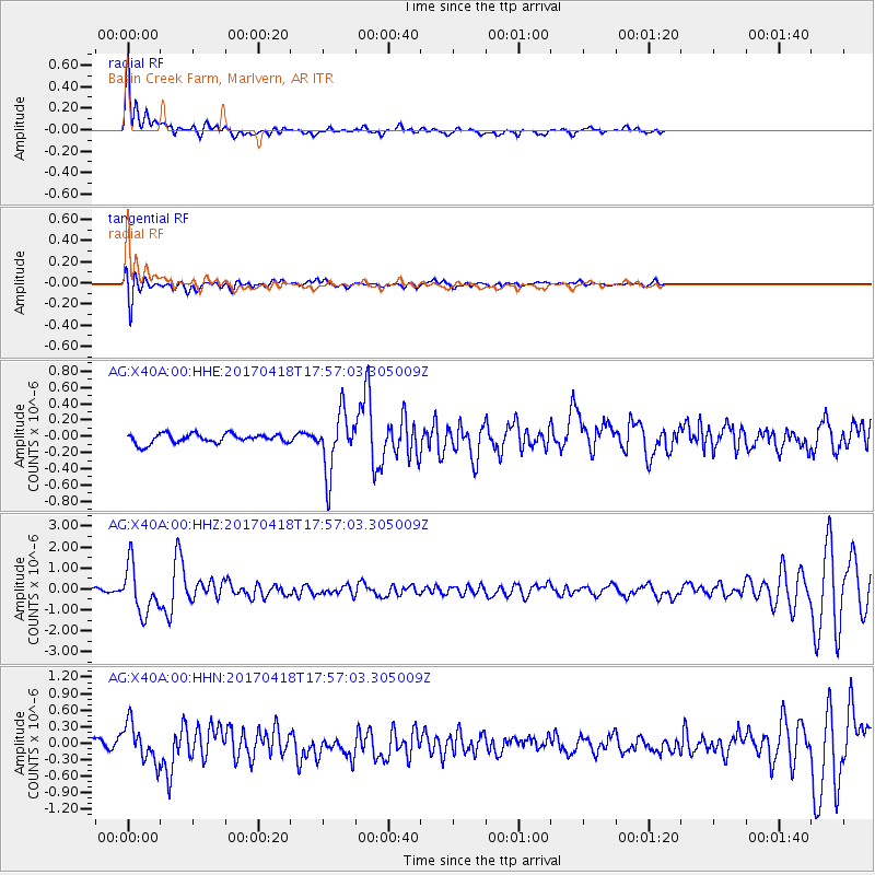
> Station X40A Basin Creek Farm, Marlvern, AR > Earthquake Result Viewer
X40A Basin Creek Farm, Marlvern, AR - Earthquake Result Viewer
| Earthquake location: |
Peru-Ecuador Border Region |
| Earthquake latitude/longitude: |
-2.7/-75.3 |
| Earthquake time(UTC): |
2017/04/18 (108) 17:49:55 GMT |
| Earthquake Depth: |
11 km |
| Earthquake Magnitude: |
6.0 Mww |
| Earthquake Catalog/Contributor: |
NEIC PDE/us |
|
| Network: |
AG Arkansas Seismic Network |
| Station: |
X40A Basin Creek Farm, Marlvern, AR |
| Lat/Lon: |
34.49 N/92.83 W |
| Elevation: |
158 m |
|
| Distance: |
40.5 deg |
| Az: |
337.487 deg |
| Baz: |
152.417 deg |
| Ray Param: |
0.07435052 |
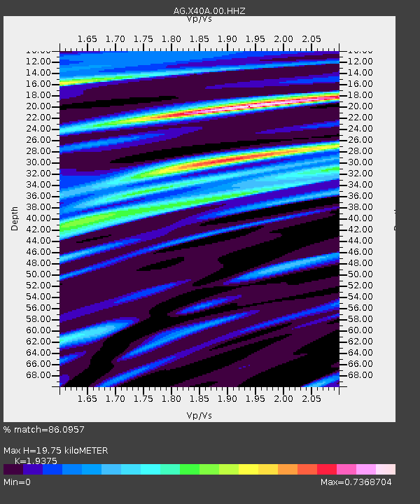
| Estimated Moho Depth: |
19.75 km |
| Estimated Crust Vp/Vs: |
1.94 |
| Assumed Crust Vp: |
6.498 km/s |
| Estimated Crust Vs: |
3.354 km/s |
| Estimated Crust Poisson's Ratio: |
0.32 |
|
| Radial Match: |
86.0957 % |
| Radial Bump: |
400 |
| Transverse Match: |
77.06173 % |
| Transverse Bump: |
400 |
| SOD ConfigId: |
2028011 |
| Insert Time: |
2017-05-02 17:50:20.459 +0000 |
| GWidth: |
2.5 |
| Max Bumps: |
400 |
| Tol: |
0.001 |
|
Signal To Noise
| Channel | StoN | STA | LTA |
| AG:X40A:00:HHZ:20170418T17:57:03.305009Z | 13.607196 | 1.1281841E-6 | 8.291084E-8 |
| AG:X40A:00:HHN:20170418T17:57:03.305009Z | 4.481597 | 3.4066048E-7 | 7.601319E-8 |
| AG:X40A:00:HHE:20170418T17:57:03.305009Z | 6.369037 | 3.6246738E-7 | 5.6910864E-8 |
| Arrivals |
| Ps | 3.0 SECOND |
| PpPs | 8.4 SECOND |
| PsPs/PpSs | 11 SECOND |


