You are here: Home > Network List > WY - Yellowstone Wyoming Seismic Network Stations List
> Station YEE East Entrance, YNP, WY, USA > Earthquake Result Viewer
YEE East Entrance, YNP, WY, USA - Earthquake Result Viewer
| Earthquake location: |
North Of Ascension Island |
| Earthquake latitude/longitude: |
0.1/-17.1 |
| Earthquake time(UTC): |
2020/01/16 (016) 09:58:19 GMT |
| Earthquake Depth: |
10 km |
| Earthquake Magnitude: |
5.5 Mww |
| Earthquake Catalog/Contributor: |
NEIC PDE/us |
|
| Network: |
WY Yellowstone Wyoming Seismic Network |
| Station: |
YEE East Entrance, YNP, WY, USA |
| Lat/Lon: |
44.49 N/109.90 W |
| Elevation: |
2270 m |
|
| Distance: |
91.9 deg |
| Az: |
314.33 deg |
| Baz: |
87.96 deg |
| Ray Param: |
0.041538753 |
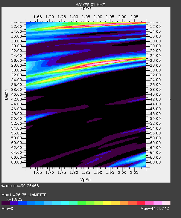
| Estimated Moho Depth: |
26.75 km |
| Estimated Crust Vp/Vs: |
1.92 |
| Assumed Crust Vp: |
6.242 km/s |
| Estimated Crust Vs: |
3.243 km/s |
| Estimated Crust Poisson's Ratio: |
0.32 |
|
| Radial Match: |
90.26465 % |
| Radial Bump: |
332 |
| Transverse Match: |
90.24697 % |
| Transverse Bump: |
352 |
| SOD ConfigId: |
20465011 |
| Insert Time: |
2020-01-30 10:11:52.168 +0000 |
| GWidth: |
2.5 |
| Max Bumps: |
400 |
| Tol: |
0.001 |
|

Signal To Noise
| Channel | StoN | STA | LTA |
| WY:YEE:01:HHZ:20200116T10:10:56.219976Z | 1.1730998 | 1.1603807E-8 | 9.891577E-9 |
| WY:YEE:01:HHN:20200116T10:10:56.219976Z | 0.7933152 | 3.0743695E-7 | 3.8753444E-7 |
| WY:YEE:01:HHE:20200116T10:10:56.219976Z | 0.8013057 | 3.7098314E-7 | 4.629733E-7 |
| Arrivals |
| Ps | 4.0 SECOND |
| PpPs | 12 SECOND |
| PsPs/PpSs | 16 SECOND |


