You are here: Home > Network List > MN - MEDNET Project Stations List
> Station TIP Timpagrande, Italy > Earthquake Result Viewer
TIP Timpagrande, Italy - Earthquake Result Viewer

| Earthquake location: |
Northern Sumatra, Indonesia |
| Earthquake latitude/longitude: |
3.4/99.1 |
| Earthquake time(UTC): |
2006/12/01 (335) 03:58:21 GMT |
| Earthquake Depth: |
206 km |
| Earthquake Magnitude: |
6.0 MB, 6.3 MW, 6.3 MW |
| Earthquake Catalog/Contributor: |
WHDF/NEIC |
|
| Network: |
MN MEDNET Project |
| Station: |
TIP Timpagrande, Italy |
| Lat/Lon: |
39.18 N/16.76 E |
| Elevation: |
789 m |
|
| Distance: |
81.9 deg |
| Az: |
308.921 deg |
| Baz: |
92.206 deg |
| Ray Param: |
0.04674715 |
| Estimated Moho Depth: |
31.75 km |
| Estimated Crust Vp/Vs: |
1.72 |
| Assumed Crust Vp: |
6.1 km/s |
| Estimated Crust Vs: |
3.541 km/s |
| Estimated Crust Poisson's Ratio: |
0.25 |
|
| Radial Match: |
80.55445 % |
| Radial Bump: |
400 |
| Transverse Match: |
77.63185 % |
| Transverse Bump: |
400 |
| SOD ConfigId: |
2564 |
| Insert Time: |
2010-03-08 17:20:32.938 +0000 |
| GWidth: |
2.5 |
| Max Bumps: |
400 |
| Tol: |
0.001 |
|
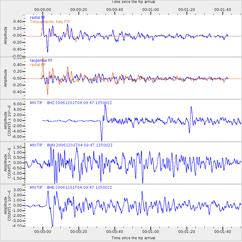
Signal To Noise
| Channel | StoN | STA | LTA |
| MN:TIP: :BHN:20061201T04:09:47.135002Z | 2.5665483 | 4.7099078E-7 | 1.8351136E-7 |
| MN:TIP: :BHE:20061201T04:09:47.135002Z | 8.83703 | 1.1209163E-6 | 1.2684309E-7 |
| MN:TIP: :BHZ:20061201T04:09:47.135002Z | 15.195734 | 2.8020963E-6 | 1.8440019E-7 |
| Arrivals |
| Ps | 3.9 SECOND |
| PpPs | 14 SECOND |
| PsPs/PpSs | 18 SECOND |


