You are here: Home > Network List > MN - MEDNET Project Stations List
> Station TIP Timpagrande, Italy > Earthquake Result Viewer
TIP Timpagrande, Italy - Earthquake Result Viewer
| Earthquake location: |
Kuril Islands |
| Earthquake latitude/longitude: |
47.0/155.0 |
| Earthquake time(UTC): |
2006/11/15 (319) 19:25:25 GMT |
| Earthquake Depth: |
10 km |
| Earthquake Magnitude: |
5.6 MB, 5.6 MS |
| Earthquake Catalog/Contributor: |
WHDF/NEIC |
|
| Network: |
MN MEDNET Project |
| Station: |
TIP Timpagrande, Italy |
| Lat/Lon: |
39.18 N/16.76 E |
| Elevation: |
789 m |
|
| Distance: |
86.4 deg |
| Az: |
328.745 deg |
| Baz: |
27.184 deg |
| Ray Param: |
0.04405123 |
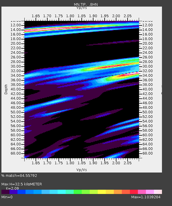
| Estimated Moho Depth: |
32.5 km |
| Estimated Crust Vp/Vs: |
2.09 |
| Assumed Crust Vp: |
6.1 km/s |
| Estimated Crust Vs: |
2.919 km/s |
| Estimated Crust Poisson's Ratio: |
0.35 |
|
| Radial Match: |
84.55792 % |
| Radial Bump: |
400 |
| Transverse Match: |
64.40356 % |
| Transverse Bump: |
400 |
| SOD ConfigId: |
2564 |
| Insert Time: |
2010-03-08 17:20:37.831 +0000 |
| GWidth: |
2.5 |
| Max Bumps: |
400 |
| Tol: |
0.001 |
|
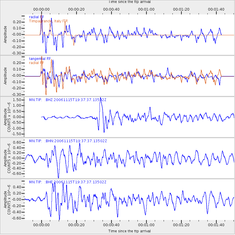
Signal To Noise
| Channel | StoN | STA | LTA |
| MN:TIP: :BHN:20061115T19:37:37.13502Z | 0.9480478 | 1.2144861E-7 | 1.2810388E-7 |
| MN:TIP: :BHE:20061115T19:37:37.13502Z | 1.450396 | 1.5881405E-7 | 1.0949703E-7 |
| MN:TIP: :BHZ:20061115T19:37:37.13502Z | 10.86226 | 7.8371863E-7 | 7.2150605E-8 |
| Arrivals |
| Ps | 5.9 SECOND |
| PpPs | 16 SECOND |
| PsPs/PpSs | 22 SECOND |


