You are here: Home > Network List > MN - MEDNET Project Stations List
> Station TIP Timpagrande, Italy > Earthquake Result Viewer
TIP Timpagrande, Italy - Earthquake Result Viewer
| Earthquake location: |
East Of Kuril Islands |
| Earthquake latitude/longitude: |
46.2/154.7 |
| Earthquake time(UTC): |
2006/11/15 (319) 12:16:44 GMT |
| Earthquake Depth: |
10 km |
| Earthquake Magnitude: |
5.9 MB |
| Earthquake Catalog/Contributor: |
WHDF/NEIC |
|
| Network: |
MN MEDNET Project |
| Station: |
TIP Timpagrande, Italy |
| Lat/Lon: |
39.18 N/16.76 E |
| Elevation: |
789 m |
|
| Distance: |
87.0 deg |
| Az: |
328.554 deg |
| Baz: |
27.79 deg |
| Ray Param: |
0.043626335 |
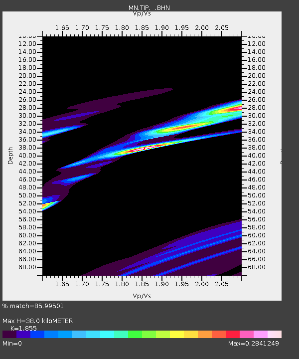
| Estimated Moho Depth: |
38.0 km |
| Estimated Crust Vp/Vs: |
1.86 |
| Assumed Crust Vp: |
6.1 km/s |
| Estimated Crust Vs: |
3.288 km/s |
| Estimated Crust Poisson's Ratio: |
0.30 |
|
| Radial Match: |
85.99501 % |
| Radial Bump: |
310 |
| Transverse Match: |
74.04469 % |
| Transverse Bump: |
278 |
| SOD ConfigId: |
2564 |
| Insert Time: |
2010-03-08 17:20:39.467 +0000 |
| GWidth: |
2.5 |
| Max Bumps: |
400 |
| Tol: |
0.001 |
|

Signal To Noise
| Channel | StoN | STA | LTA |
| MN:TIP: :BHN:20061115T12:28:58.084021Z | 1.9807839 | 1.0092049E-4 | 5.0949773E-5 |
| MN:TIP: :BHE:20061115T12:28:58.084021Z | 0.8028862 | 2.8660856E-5 | 3.569728E-5 |
| MN:TIP: :BHZ:20061115T12:28:58.084021Z | 0.8003194 | 6.725475E-5 | 8.403489E-5 |
| Arrivals |
| Ps | 5.4 SECOND |
| PpPs | 17 SECOND |
| PsPs/PpSs | 23 SECOND |


