You are here: Home > Network List > MN - MEDNET Project Stations List
> Station TIP Timpagrande, Italy > Earthquake Result Viewer
TIP Timpagrande, Italy - Earthquake Result Viewer
| Earthquake location: |
Philippine Islands Region |
| Earthquake latitude/longitude: |
20.7/120.1 |
| Earthquake time(UTC): |
2006/10/11 (284) 06:43:53 GMT |
| Earthquake Depth: |
10 km |
| Earthquake Magnitude: |
5.7 MB, 5.7 MW, 5.7 MW |
| Earthquake Catalog/Contributor: |
WHDF/NEIC |
|
| Network: |
MN MEDNET Project |
| Station: |
TIP Timpagrande, Italy |
| Lat/Lon: |
39.18 N/16.76 E |
| Elevation: |
789 m |
|
| Distance: |
86.9 deg |
| Az: |
310.764 deg |
| Baz: |
65.819 deg |
| Ray Param: |
0.043691017 |
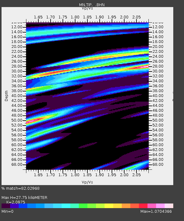
| Estimated Moho Depth: |
27.75 km |
| Estimated Crust Vp/Vs: |
2.10 |
| Assumed Crust Vp: |
6.1 km/s |
| Estimated Crust Vs: |
2.908 km/s |
| Estimated Crust Poisson's Ratio: |
0.35 |
|
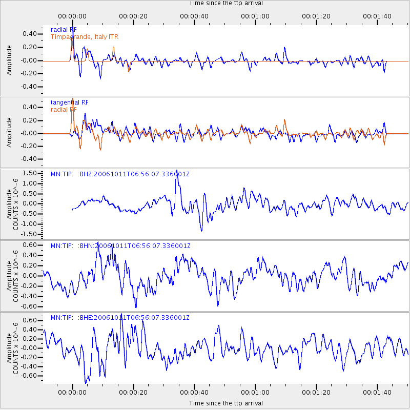
| Radial Match: |
82.02968 % |
| Radial Bump: |
400 |
| Transverse Match: |
88.24371 % |
| Transverse Bump: |
400 |
| SOD ConfigId: |
2665 |
| Insert Time: |
2010-03-08 17:20:45.279 +0000 |
| GWidth: |
2.5 |
| Max Bumps: |
400 |
| Tol: |
0.001 |
|
Signal To Noise
| Channel | StoN | STA | LTA |
| MN:TIP: :BHN:20061011T06:56:07.336001Z | 1.0452147 | 2.0868745E-7 | 1.9965992E-7 |
| MN:TIP: :BHE:20061011T06:56:07.336001Z | 2.0112855 | 3.3557697E-7 | 1.66847E-7 |
| MN:TIP: :BHZ:20061011T06:56:07.336001Z | 3.1705654 | 6.881619E-7 | 2.1704706E-7 |
| Arrivals |
| Ps | 5.1 SECOND |
| PpPs | 14 SECOND |
| PsPs/PpSs | 19 SECOND |


