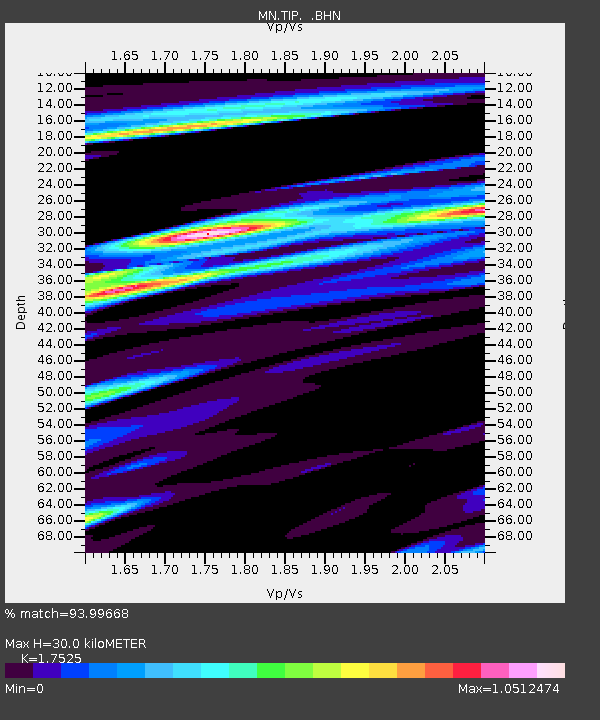
TIP Timpagrande, Italy - Earthquake Result Viewer
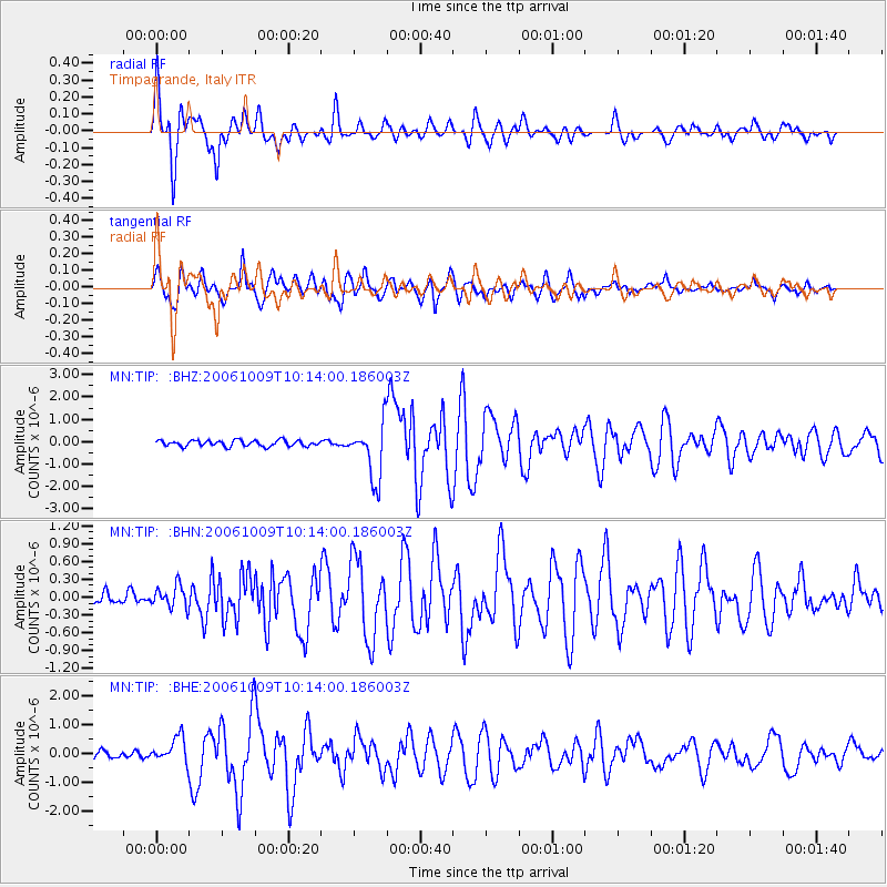
Earthquake location: Philippine Islands Region
Earthquake latitude/longitude: 20.7/120.0
Earthquake time(UTC): 2006/10/09 (282) 10:01:46 GMT
Earthquake Depth: 10 km
Earthquake Magnitude: 6.0 MB, 5.9 MS, 6.3 MW, 6.1 MW
Earthquake Catalog/Contributor: WHDF/NEIC
Network: MN MEDNET Project
Station: TIP Timpagrande, Italy
Lat/Lon: 39.18 N/16.76 E
Elevation: 789 m
Distance: 86.9 deg
Az: 310.745 deg
Baz: 65.906 deg
Ray Param: 0.043697804
Estimated Moho Depth: 30.0 km
Estimated Crust Vp/Vs: 1.75
Assumed Crust Vp: 6.1 km/s
Estimated Crust Vs: 3.481 km/s
Estimated Crust Poisson's Ratio: 0.26
Radial Match: 93.99668 %
Radial Bump: 400
Transverse Match: 89.11893 %
Transverse Bump: 400
SOD ConfigId: 2665
Insert Time: 2010-03-08 17:20:46.363 +0000
GWidth: 2.5
Max Bumps: 400
Tol: 0.001

Signal To Noise

ChannelStoNSTALTA
MN:TIP: :BHN:20061009T10:14:00.186003Z2.10308581.8675198E-78.8799034E-8
MN:TIP: :BHE:20061009T10:14:00.186003Z3.42224344.417983E-71.2909611E-7
MN:TIP: :BHZ:20061009T10:14:00.186003Z9.3994681.2462475E-61.3258702E-7
Arrivals
Ps3.8 SECOND
PpPs13 SECOND
PsPs/PpSs17 SECOND