You are here: Home > Network List > MN - MEDNET Project Stations List
> Station TIP Timpagrande, Italy > Earthquake Result Viewer
TIP Timpagrande, Italy - Earthquake Result Viewer
| Earthquake location: |
Central Mid-Atlantic Ridge |
| Earthquake latitude/longitude: |
7.3/-34.7 |
| Earthquake time(UTC): |
2006/09/30 (273) 12:47:22 GMT |
| Earthquake Depth: |
10 km |
| Earthquake Magnitude: |
5.6 MB, 5.0 MS, 5.5 MW |
| Earthquake Catalog/Contributor: |
WHDF/NEIC |
|
| Network: |
MN MEDNET Project |
| Station: |
TIP Timpagrande, Italy |
| Lat/Lon: |
39.18 N/16.76 E |
| Elevation: |
789 m |
|
| Distance: |
55.9 deg |
| Az: |
47.173 deg |
| Baz: |
249.405 deg |
| Ray Param: |
0.064468645 |
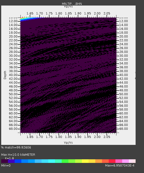
| Estimated Moho Depth: |
10.0 km |
| Estimated Crust Vp/Vs: |
1.60 |
| Assumed Crust Vp: |
6.1 km/s |
| Estimated Crust Vs: |
3.812 km/s |
| Estimated Crust Poisson's Ratio: |
0.18 |
|
| Radial Match: |
99.92606 % |
| Radial Bump: |
15 |
| Transverse Match: |
99.91125 % |
| Transverse Bump: |
14 |
| SOD ConfigId: |
2665 |
| Insert Time: |
2010-03-08 17:20:47.563 +0000 |
| GWidth: |
2.5 |
| Max Bumps: |
400 |
| Tol: |
0.001 |
|
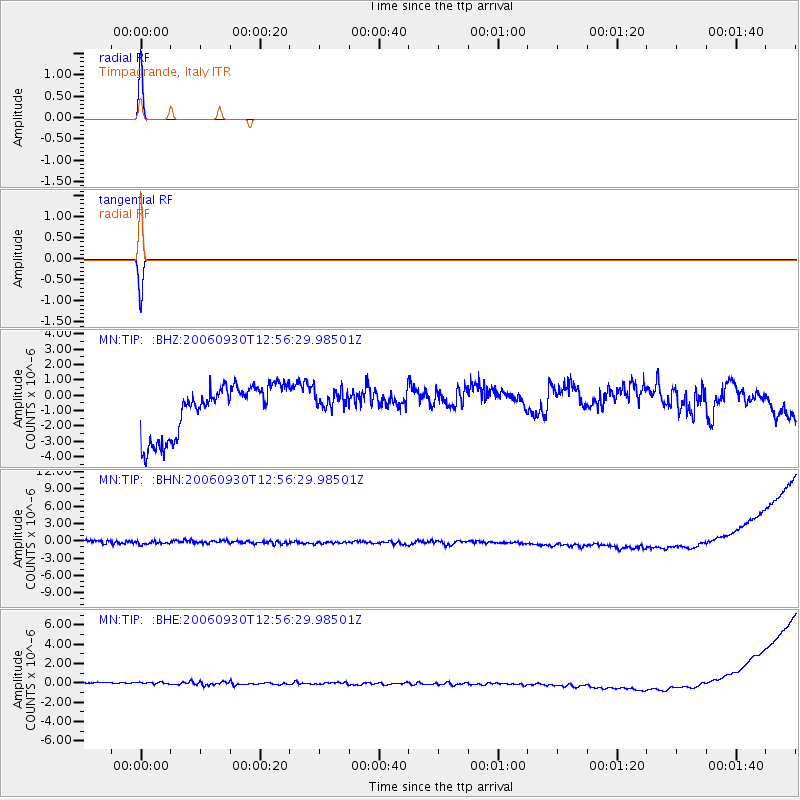
Signal To Noise
| Channel | StoN | STA | LTA |
| MN:TIP: :BHN:20060930T12:56:29.98501Z | 0.6394357 | 6.3521014E-7 | 9.933917E-7 |
| MN:TIP: :BHE:20060930T12:56:29.98501Z | 0.94908965 | 5.416033E-7 | 5.706556E-7 |
| MN:TIP: :BHZ:20060930T12:56:29.98501Z | 0.45178804 | 7.390313E-7 | 1.6357922E-6 |
| Arrivals |
| Ps | 1.0 SECOND |
| PpPs | 4.0 SECOND |
| PsPs/PpSs | 5.1 SECOND |


