You are here: Home > Network List > MN - MEDNET Project Stations List
> Station TIP Timpagrande, Italy > Earthquake Result Viewer
TIP Timpagrande, Italy - Earthquake Result Viewer
| Earthquake location: |
Gulf Of Mexico |
| Earthquake latitude/longitude: |
26.3/-86.6 |
| Earthquake time(UTC): |
2006/09/10 (253) 14:56:08 GMT |
| Earthquake Depth: |
14 km |
| Earthquake Magnitude: |
5.9 MB, 5.5 MS, 5.8 MW, 5.8 MW |
| Earthquake Catalog/Contributor: |
WHDF/NEIC |
|
| Network: |
MN MEDNET Project |
| Station: |
TIP Timpagrande, Italy |
| Lat/Lon: |
39.18 N/16.76 E |
| Elevation: |
789 m |
|
| Distance: |
83.3 deg |
| Az: |
49.584 deg |
| Baz: |
298.458 deg |
| Ray Param: |
0.046261128 |
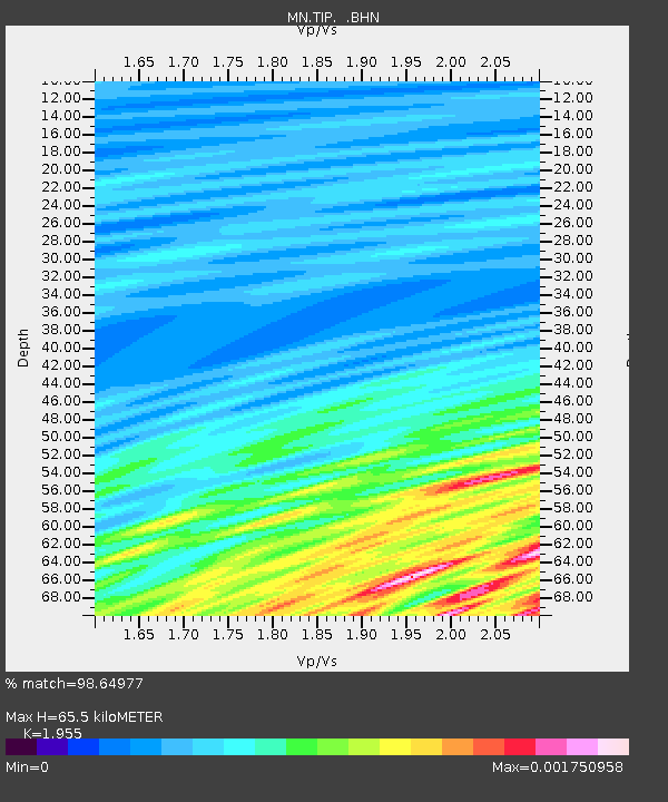
| Estimated Moho Depth: |
65.5 km |
| Estimated Crust Vp/Vs: |
1.96 |
| Assumed Crust Vp: |
6.1 km/s |
| Estimated Crust Vs: |
3.12 km/s |
| Estimated Crust Poisson's Ratio: |
0.32 |
|
| Radial Match: |
98.64977 % |
| Radial Bump: |
238 |
| Transverse Match: |
99.945435 % |
| Transverse Bump: |
16 |
| SOD ConfigId: |
2665 |
| Insert Time: |
2010-03-08 17:20:51.353 +0000 |
| GWidth: |
2.5 |
| Max Bumps: |
400 |
| Tol: |
0.001 |
|
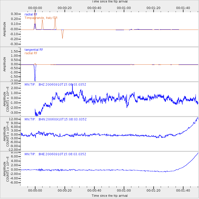
Signal To Noise
| Channel | StoN | STA | LTA |
| MN:TIP: :BHN:20060910T15:08:03.035Z | 1.0613241 | 2.8307697E-6 | 2.6672058E-6 |
| MN:TIP: :BHE:20060910T15:08:03.035Z | 0.9976326 | 5.4781214E-7 | 5.4911214E-7 |
| MN:TIP: :BHZ:20060910T15:08:03.035Z | 0.97607094 | 1.3996341E-6 | 1.4339471E-6 |
| Arrivals |
| Ps | 10 SECOND |
| PpPs | 31 SECOND |
| PsPs/PpSs | 42 SECOND |


