You are here: Home > Network List > MN - MEDNET Project Stations List
> Station TIP Timpagrande, Italy > Earthquake Result Viewer
TIP Timpagrande, Italy - Earthquake Result Viewer
| Earthquake location: |
Central Peru |
| Earthquake latitude/longitude: |
-14.4/-70.7 |
| Earthquake time(UTC): |
2006/08/09 (221) 22:36:08 GMT |
| Earthquake Depth: |
29 km |
| Earthquake Magnitude: |
5.6 MB, 4.6 MS, 5.2 MW, 5.2 ML |
| Earthquake Catalog/Contributor: |
WHDF/NEIC |
|
| Network: |
MN MEDNET Project |
| Station: |
TIP Timpagrande, Italy |
| Lat/Lon: |
39.18 N/16.76 E |
| Elevation: |
789 m |
|
| Distance: |
97.1 deg |
| Az: |
51.484 deg |
| Baz: |
257.249 deg |
| Ray Param: |
0.040315244 |
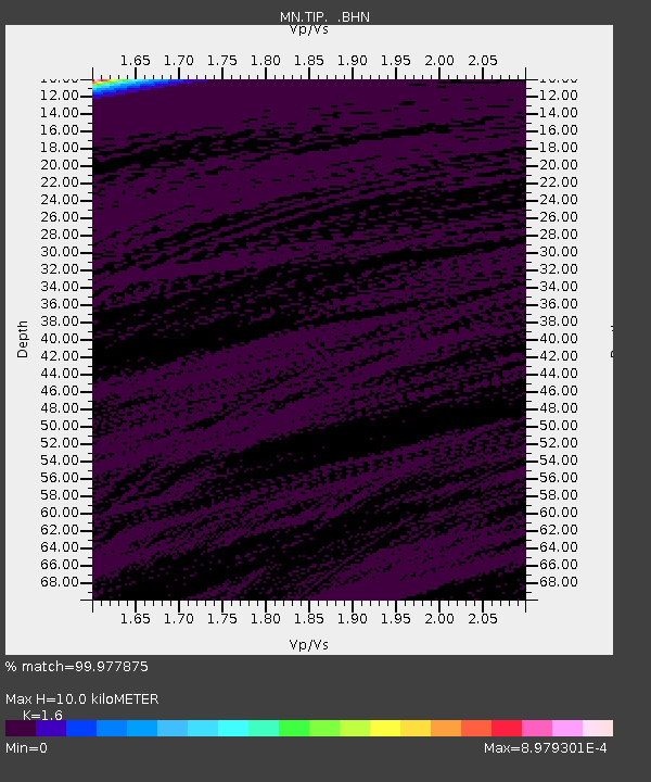
| Estimated Moho Depth: |
10.0 km |
| Estimated Crust Vp/Vs: |
1.60 |
| Assumed Crust Vp: |
6.1 km/s |
| Estimated Crust Vs: |
3.812 km/s |
| Estimated Crust Poisson's Ratio: |
0.18 |
|
| Radial Match: |
99.977875 % |
| Radial Bump: |
2 |
| Transverse Match: |
99.88968 % |
| Transverse Bump: |
6 |
| SOD ConfigId: |
2665 |
| Insert Time: |
2010-03-08 17:20:53.320 +0000 |
| GWidth: |
2.5 |
| Max Bumps: |
400 |
| Tol: |
0.001 |
|
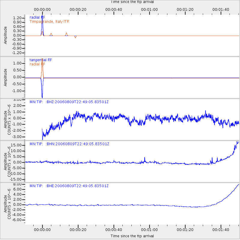
Signal To Noise
| Channel | StoN | STA | LTA |
| MN:TIP: :BHN:20060809T22:49:05.83501Z | 1.5334566 | 1.6032947E-6 | 1.045543E-6 |
| MN:TIP: :BHE:20060809T22:49:05.83501Z | 1.0520084 | 6.996439E-7 | 6.650555E-7 |
| MN:TIP: :BHZ:20060809T22:49:05.83501Z | 1.1005337 | 1.1978751E-6 | 1.0884493E-6 |
| Arrivals |
| Ps | 1.0 SECOND |
| PpPs | 4.2 SECOND |
| PsPs/PpSs | 5.2 SECOND |


