You are here: Home > Network List > MN - MEDNET Project Stations List
> Station TIP Timpagrande, Italy > Earthquake Result Viewer
TIP Timpagrande, Italy - Earthquake Result Viewer
| Earthquake location: |
North Atlantic Ocean |
| Earthquake latitude/longitude: |
23.6/-63.9 |
| Earthquake time(UTC): |
2006/07/29 (210) 19:53:43 GMT |
| Earthquake Depth: |
10 km |
| Earthquake Magnitude: |
5.5 MB, 5.0 MS, 5.8 MW, 5.6 MW |
| Earthquake Catalog/Contributor: |
WHDF/NEIC |
|
| Network: |
MN MEDNET Project |
| Station: |
TIP Timpagrande, Italy |
| Lat/Lon: |
39.18 N/16.76 E |
| Elevation: |
789 m |
|
| Distance: |
68.5 deg |
| Az: |
55.499 deg |
| Baz: |
283.408 deg |
| Ray Param: |
0.05623637 |
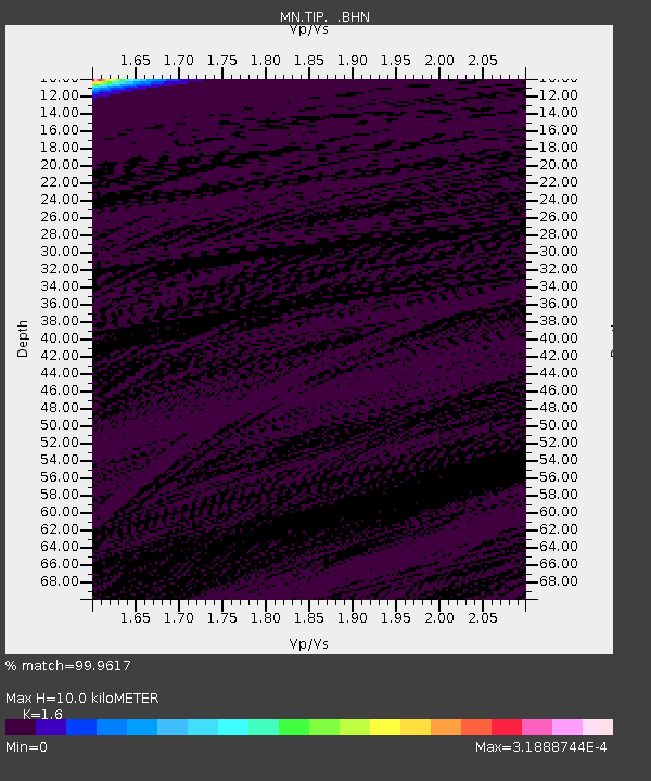
| Estimated Moho Depth: |
10.0 km |
| Estimated Crust Vp/Vs: |
1.60 |
| Assumed Crust Vp: |
6.1 km/s |
| Estimated Crust Vs: |
3.812 km/s |
| Estimated Crust Poisson's Ratio: |
0.18 |
|
| Radial Match: |
99.9617 % |
| Radial Bump: |
2 |
| Transverse Match: |
99.96261 % |
| Transverse Bump: |
2 |
| SOD ConfigId: |
2665 |
| Insert Time: |
2010-03-08 17:20:54.497 +0000 |
| GWidth: |
2.5 |
| Max Bumps: |
400 |
| Tol: |
0.001 |
|
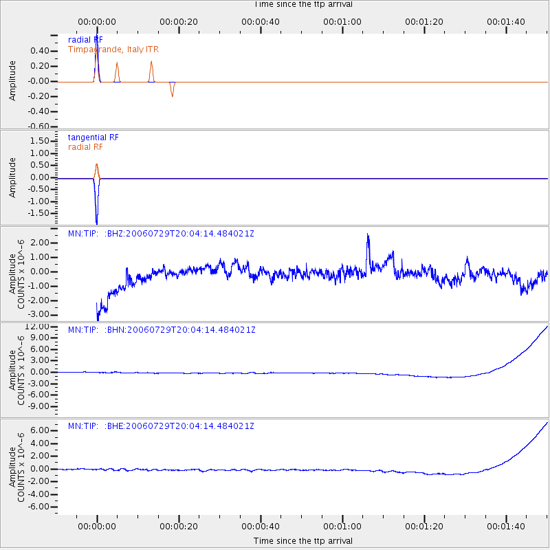
Signal To Noise
| Channel | StoN | STA | LTA |
| MN:TIP: :BHN:20060729T20:04:14.484021Z | 0.9173907 | 9.347727E-7 | 1.0189472E-6 |
| MN:TIP: :BHE:20060729T20:04:14.484021Z | 0.8971622 | 5.558577E-7 | 6.1957326E-7 |
| MN:TIP: :BHZ:20060729T20:04:14.484021Z | 1.1924576 | 1.0555426E-6 | 8.851825E-7 |
| Arrivals |
| Ps | 1.0 SECOND |
| PpPs | 4.1 SECOND |
| PsPs/PpSs | 5.1 SECOND |


