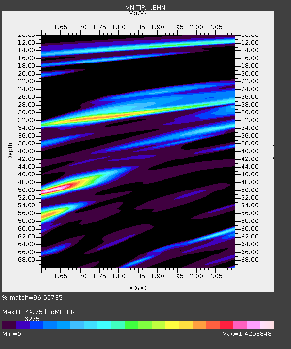
TIP Timpagrande, Italy - Earthquake Result Viewer
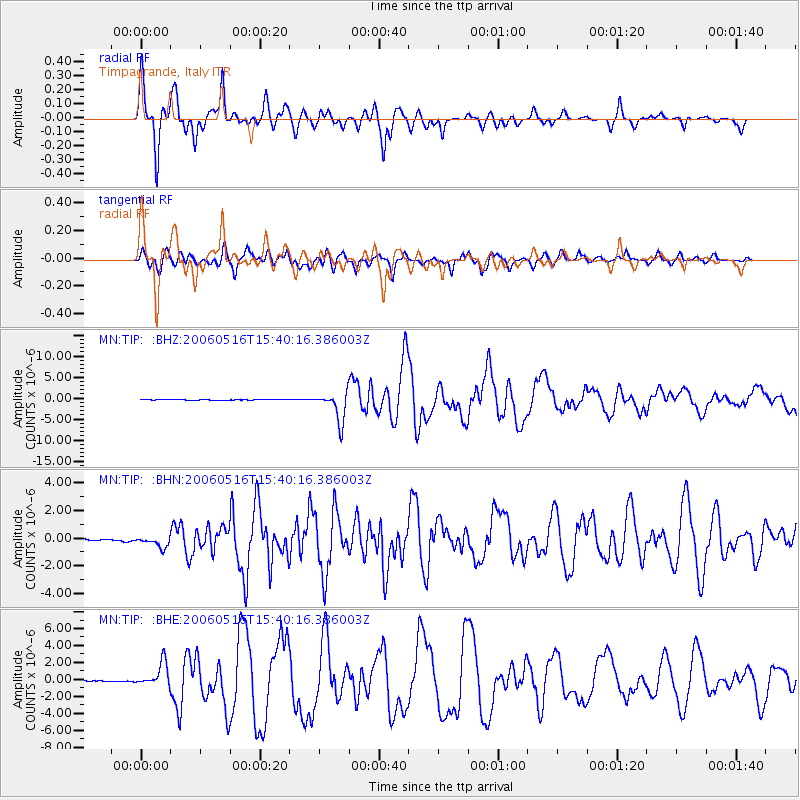
Earthquake location: Northern Sumatra, Indonesia
Earthquake latitude/longitude: 0.1/97.1
Earthquake time(UTC): 2006/05/16 (136) 15:28:25 GMT
Earthquake Depth: 12 km
Earthquake Magnitude: 6.6 MB, 6.8 MS, 6.8 MW, 6.8 MW
Earthquake Catalog/Contributor: WHDF/NEIC
Network: MN MEDNET Project
Station: TIP Timpagrande, Italy
Lat/Lon: 39.18 N/16.76 E
Elevation: 789 m
Distance: 82.4 deg
Az: 309.386 deg
Baz: 96.072 deg
Ray Param: 0.046903107
Estimated Moho Depth: 49.75 km
Estimated Crust Vp/Vs: 1.63
Assumed Crust Vp: 6.1 km/s
Estimated Crust Vs: 3.748 km/s
Estimated Crust Poisson's Ratio: 0.20
Radial Match: 96.50735 %
Radial Bump: 400
Transverse Match: 89.49617 %
Transverse Bump: 400
SOD ConfigId: 2669
Insert Time: 2010-03-08 17:21:02.493 +0000
GWidth: 2.5
Max Bumps: 400
Tol: 0.001

Signal To Noise

ChannelStoNSTALTA
MN:TIP: :BHN:20060516T15:40:16.386003Z7.70400054.3818503E-75.6877596E-8
MN:TIP: :BHE:20060516T15:40:16.386003Z22.1388131.4153676E-66.39315E-8
MN:TIP: :BHZ:20060516T15:40:16.386003Z57.9109423.5059427E-66.0540245E-8
Arrivals
Ps5.3 SECOND
PpPs21 SECOND
PsPs/PpSs26 SECOND