You are here: Home > Network List > IU - Global Seismograph Network (GSN - IRIS/USGS) Stations List
> Station MAKZ Makanchi, Kazakhstan > Earthquake Result Viewer
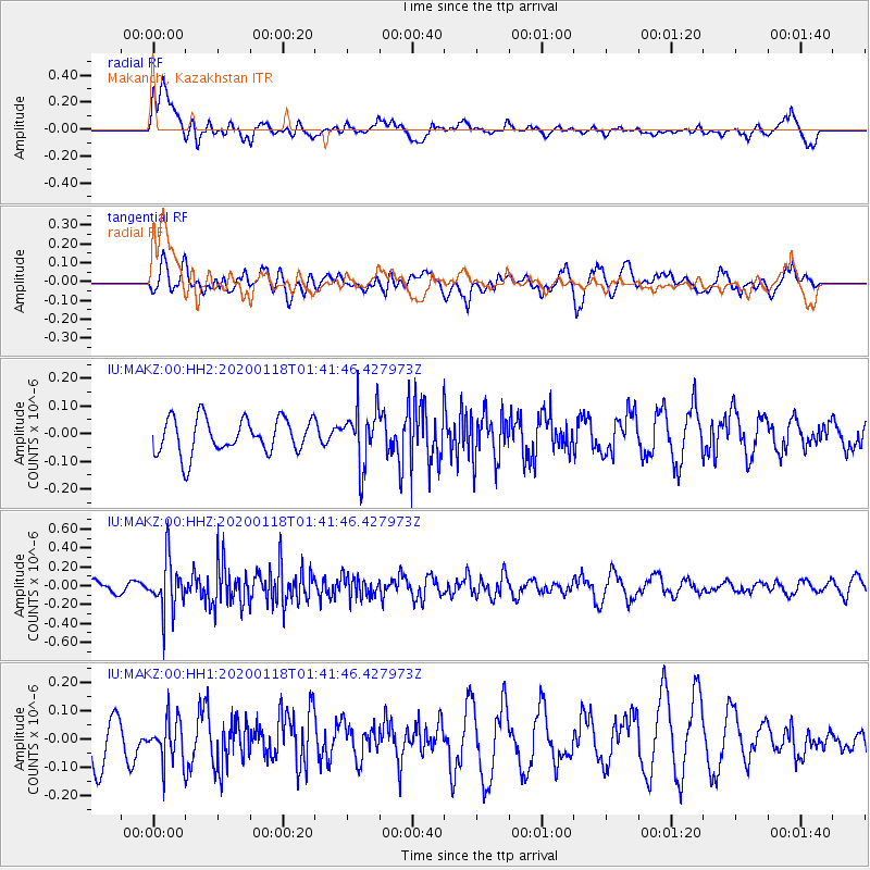
MAKZ Makanchi, Kazakhstan - Earthquake Result Viewer
*The percent match for this event was below the threshold and hence no stack was calculated.
| Earthquake location: |
Tanimbar Islands Reg., Indonesia |
| Earthquake latitude/longitude: |
-6.6/132.1 |
| Earthquake time(UTC): |
2020/01/18 (018) 01:31:10 GMT |
| Earthquake Depth: |
10 km |
| Earthquake Magnitude: |
5.0 Mww |
| Earthquake Catalog/Contributor: |
NEIC PDE/us |
|
| Network: |
IU Global Seismograph Network (GSN - IRIS/USGS) |
| Station: |
MAKZ Makanchi, Kazakhstan |
| Lat/Lon: |
46.81 N/81.98 E |
| Elevation: |
600 m |
|
| Distance: |
69.3 deg |
| Az: |
325.669 deg |
| Baz: |
125.346 deg |
| Ray Param: |
$rayparam |
*The percent match for this event was below the threshold and hence was not used in the summary stack. |
|
| Radial Match: |
61.487278 % |
| Radial Bump: |
400 |
| Transverse Match: |
36.760174 % |
| Transverse Bump: |
380 |
| SOD ConfigId: |
20465011 |
| Insert Time: |
2020-02-01 01:34:08.889 +0000 |
| GWidth: |
2.5 |
| Max Bumps: |
400 |
| Tol: |
0.001 |
|
Signal To Noise
| Channel | StoN | STA | LTA |
| IU:MAKZ:00:HHZ:20200118T01:41:46.427973Z | 2.9743824 | 2.7604943E-7 | 9.2808996E-8 |
| IU:MAKZ:00:HH1:20200118T01:41:46.427973Z | 0.82766277 | 7.6913246E-8 | 9.292824E-8 |
| IU:MAKZ:00:HH2:20200118T01:41:46.427973Z | 1.6243439 | 1.02798914E-7 | 6.328642E-8 |
| Arrivals |
| Ps | |
| PpPs | |
| PsPs/PpSs | |


