TIP Timpagrande, Italy - Earthquake Result Viewer
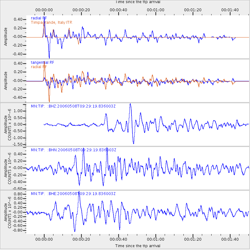
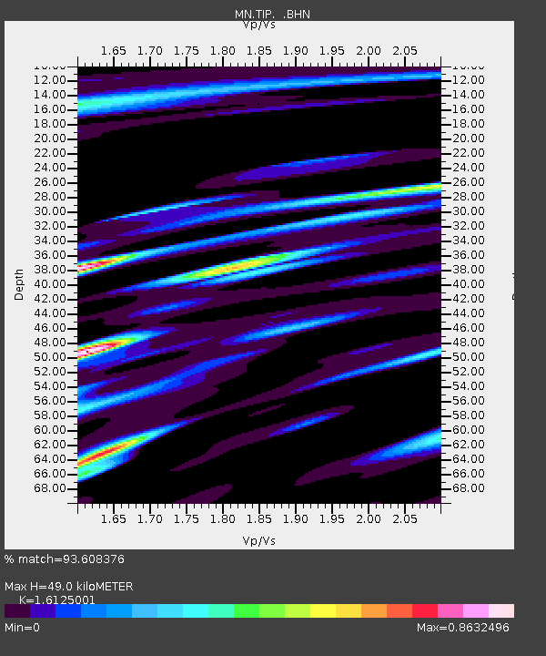
Earthquake location: Southern Sumatra, Indonesia
Earthquake latitude/longitude: -4.8/102.4
Earthquake time(UTC): 2006/05/08 (128) 09:16:57 GMT
Earthquake Depth: 43 km
Earthquake Magnitude: 5.8 MB, 5.7 MS, 5.9 MW, 5.8 MW
Earthquake Catalog/Contributor: WHDF/NEIC
Network: MN MEDNET Project
Station: TIP Timpagrande, Italy
Lat/Lon: 39.18 N/16.76 E
Elevation: 789 m
Distance: 89.6 deg
Az: 309.198 deg
Baz: 96.502 deg
Ray Param: 0.041726
Estimated Moho Depth: 49.0 km
Estimated Crust Vp/Vs: 1.61
Assumed Crust Vp: 6.1 km/s
Estimated Crust Vs: 3.783 km/s
Estimated Crust Poisson's Ratio: 0.19
Radial Match: 93.608376 %
Radial Bump: 400
Transverse Match: 77.207466 %
Transverse Bump: 400
SOD ConfigId: 2669
Insert Time: 2010-03-08 17:21:03.616 +0000
GWidth: 2.5
Max Bumps: 400
Tol: 0.001

Signal To Noise

ChannelStoNSTALTA
MN:TIP: :BHN:20060508T09:29:19.836003Z1.03974775.0778645E-84.8837467E-8
MN:TIP: :BHE:20060508T09:29:19.836003Z3.14224481.4198818E-74.5186862E-8
MN:TIP: :BHZ:20060508T09:29:19.836003Z6.0836653.5074237E-75.7653132E-8
Arrivals
Ps5.0 SECOND
PpPs21 SECOND
PsPs/PpSs26 SECOND