You are here: Home > Network List > ET - CERI Southern Appalachian seismic Network Stations List
> Station FPAL Fort Payne,AL > Earthquake Result Viewer
FPAL Fort Payne,AL - Earthquake Result Viewer
| Earthquake location: |
Peru-Ecuador Border Region |
| Earthquake latitude/longitude: |
-2.7/-75.3 |
| Earthquake time(UTC): |
2017/04/18 (108) 17:49:55 GMT |
| Earthquake Depth: |
11 km |
| Earthquake Magnitude: |
6.0 Mww |
| Earthquake Catalog/Contributor: |
NEIC PDE/us |
|
| Network: |
ET CERI Southern Appalachian seismic Network |
| Station: |
FPAL Fort Payne,AL |
| Lat/Lon: |
34.54 N/85.61 W |
| Elevation: |
556 m |
|
| Distance: |
38.3 deg |
| Az: |
346.219 deg |
| Baz: |
163.248 deg |
| Ray Param: |
0.07563049 |
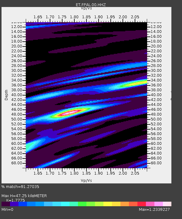
| Estimated Moho Depth: |
47.25 km |
| Estimated Crust Vp/Vs: |
1.78 |
| Assumed Crust Vp: |
6.35 km/s |
| Estimated Crust Vs: |
3.572 km/s |
| Estimated Crust Poisson's Ratio: |
0.27 |
|
| Radial Match: |
91.27035 % |
| Radial Bump: |
278 |
| Transverse Match: |
50.806217 % |
| Transverse Bump: |
400 |
| SOD ConfigId: |
2028011 |
| Insert Time: |
2017-05-02 17:53:25.528 +0000 |
| GWidth: |
2.5 |
| Max Bumps: |
400 |
| Tol: |
0.001 |
|

Signal To Noise
| Channel | StoN | STA | LTA |
| ET:FPAL:00:HHZ:20170418T17:56:44.925004Z | 17.064323 | 1.8853874E-6 | 1.1048709E-7 |
| ET:FPAL:00:HHN:20170418T17:56:44.925004Z | 14.583502 | 1.1595064E-6 | 7.950809E-8 |
| ET:FPAL:00:HHE:20170418T17:56:44.925004Z | 2.9718623 | 3.3429174E-7 | 1.1248561E-7 |
| Arrivals |
| Ps | 6.2 SECOND |
| PpPs | 19 SECOND |
| PsPs/PpSs | 25 SECOND |


