You are here: Home > Network List > ET - CERI Southern Appalachian seismic Network Stations List
> Station SWET Sewanee,TN > Earthquake Result Viewer
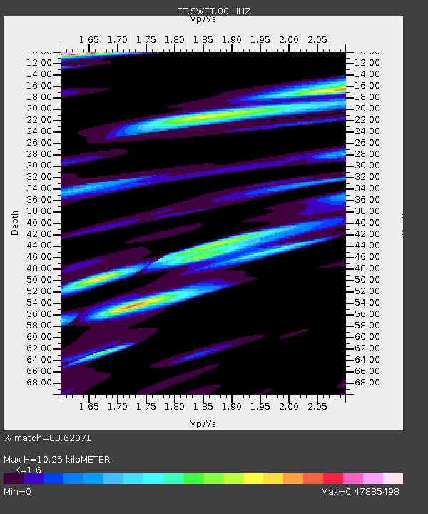
SWET Sewanee,TN - Earthquake Result Viewer
| Earthquake location: |
Peru-Ecuador Border Region |
| Earthquake latitude/longitude: |
-2.7/-75.3 |
| Earthquake time(UTC): |
2017/04/18 (108) 17:49:55 GMT |
| Earthquake Depth: |
11 km |
| Earthquake Magnitude: |
6.0 Mww |
| Earthquake Catalog/Contributor: |
NEIC PDE/us |
|
| Network: |
ET CERI Southern Appalachian seismic Network |
| Station: |
SWET Sewanee,TN |
| Lat/Lon: |
35.22 N/85.93 W |
| Elevation: |
581 m |
|
| Distance: |
39.0 deg |
| Az: |
346.129 deg |
| Baz: |
162.994 deg |
| Ray Param: |
0.07521348 |
| Estimated Moho Depth: |
10.25 km |
| Estimated Crust Vp/Vs: |
1.60 |
| Assumed Crust Vp: |
6.35 km/s |
| Estimated Crust Vs: |
3.969 km/s |
| Estimated Crust Poisson's Ratio: |
0.18 |
|
| Radial Match: |
88.62071 % |
| Radial Bump: |
299 |
| Transverse Match: |
69.145515 % |
| Transverse Bump: |
400 |
| SOD ConfigId: |
2028011 |
| Insert Time: |
2017-05-02 17:53:28.441 +0000 |
| GWidth: |
2.5 |
| Max Bumps: |
400 |
| Tol: |
0.001 |
|

Signal To Noise
| Channel | StoN | STA | LTA |
| ET:SWET:00:HHZ:20170418T17:56:50.974991Z | 13.250015 | 1.896089E-6 | 1.4310088E-7 |
| ET:SWET:00:HHN:20170418T17:56:50.974991Z | 8.589868 | 1.1745957E-6 | 1.36742E-7 |
| ET:SWET:00:HHE:20170418T17:56:50.974991Z | 2.6070206 | 2.2443783E-7 | 8.608978E-8 |
| Arrivals |
| Ps | 1.0 SECOND |
| PpPs | 3.9 SECOND |
| PsPs/PpSs | 4.9 SECOND |


