You are here: Home > Network List > MN - MEDNET Project Stations List
> Station TIP Timpagrande, Italy > Earthquake Result Viewer
TIP Timpagrande, Italy - Earthquake Result Viewer

| Earthquake location: |
Kuril Islands |
| Earthquake latitude/longitude: |
46.0/151.5 |
| Earthquake time(UTC): |
2009/04/07 (097) 04:23:33 GMT |
| Earthquake Depth: |
31 km |
| Earthquake Magnitude: |
6.5 MB, 6.8 MS, 6.9 MW, 6.9 MW |
| Earthquake Catalog/Contributor: |
WHDF/NEIC |
|
| Network: |
MN MEDNET Project |
| Station: |
TIP Timpagrande, Italy |
| Lat/Lon: |
39.18 N/16.76 E |
| Elevation: |
789 m |
|
| Distance: |
86.0 deg |
| Az: |
326.429 deg |
| Baz: |
29.702 deg |
| Ray Param: |
0.044340547 |
| Estimated Moho Depth: |
29.5 km |
| Estimated Crust Vp/Vs: |
1.94 |
| Assumed Crust Vp: |
6.1 km/s |
| Estimated Crust Vs: |
3.148 km/s |
| Estimated Crust Poisson's Ratio: |
0.32 |
|
| Radial Match: |
92.859535 % |
| Radial Bump: |
400 |
| Transverse Match: |
89.92569 % |
| Transverse Bump: |
400 |
| SOD ConfigId: |
2658 |
| Insert Time: |
2010-03-08 17:21:10.203 +0000 |
| GWidth: |
2.5 |
| Max Bumps: |
400 |
| Tol: |
0.001 |
|
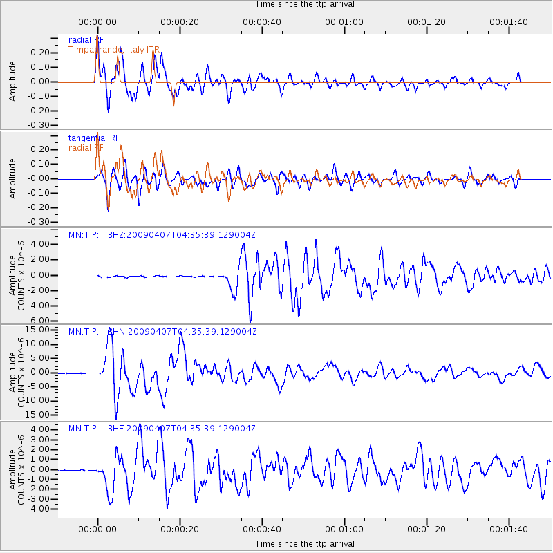
Signal To Noise
| Channel | StoN | STA | LTA |
| MN:TIP: :BHN:20090407T04:35:39.129004Z | 124.38971 | 8.986371E-6 | 7.224369E-8 |
| MN:TIP: :BHE:20090407T04:35:39.129004Z | 25.738987 | 1.753428E-6 | 6.8123434E-8 |
| MN:TIP: :BHZ:20090407T04:35:39.129004Z | 20.20002 | 1.4924798E-6 | 7.388507E-8 |
| Arrivals |
| Ps | 4.6 SECOND |
| PpPs | 14 SECOND |
| PsPs/PpSs | 19 SECOND |


